Overview
As a snow lover obsessed with winter storms, the early to mid 1970s was bereft of snowstorms. Even when snow fell, it inevitably changed to rain (breaking the heart of this young snow lover), and I do not have any recollections of significant winter weather during this period. However, that started to change during the winter of 1976-1977. There was not much in the way of snow (at least along the Jersey Shore near Toms River, NJ), that winter, but it was the coldest I had ever experienced. January 1977 was more than 11 degrees below normal, and we had our first subzero mornings in my memory (in fact we had four in a row!). Unfortunately, like most winters, once the precipitation arrived, temperatures warmed sufficiently to ensure that the precipitation fell mostly in the form of rain along the coast.
The winter of 1977-1978 was not nearly as cold as the previous winter, but we did have a few snowfalls during January, which whetted my appetite for even more winter weather. A blizzard affecting the Ohio Valley during January 1978 produced a few inches of snow near the coast, but even this storm saw the snow to change to rain (and freezing rain in northern NJ, where the Chicago Bears played the New York Giants on a wintry Sunday afternoon). Despite the disappointment, I was happy to see the snow, and though I did not yet know it, the biggest snowstorm of my young life was just a couple of weeks away.
Before the Storm: early February 1978
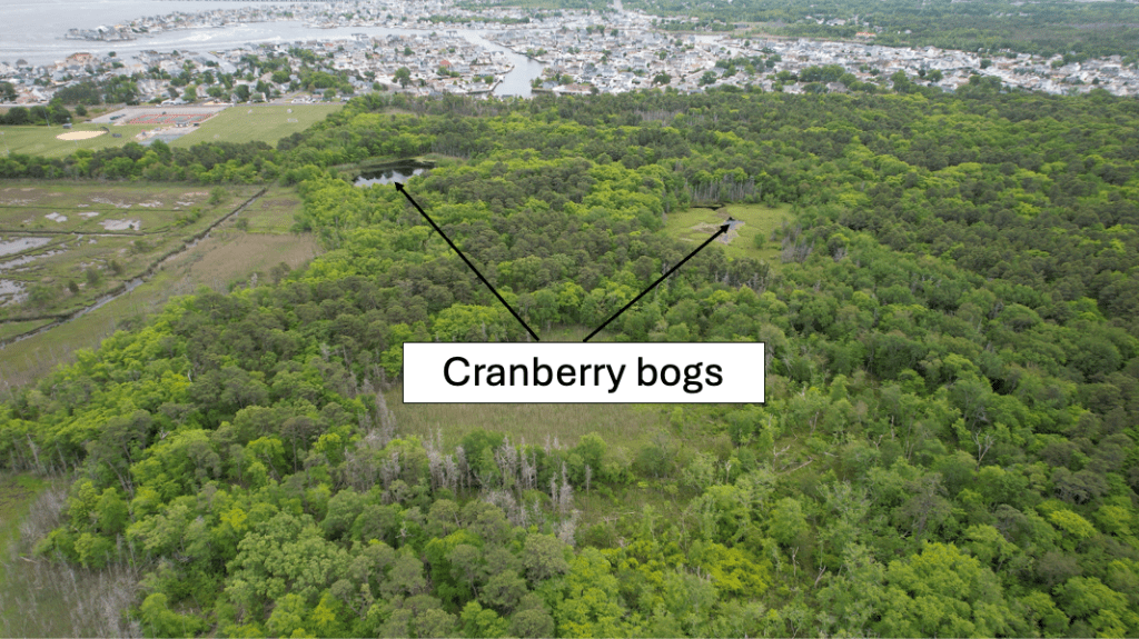
Despite sunshine during the early days of February 1978, temperatures remained below freezing during the entire time, which was highly unusual for the Jersey Shore. My younger sister and I would frequent the cranberry bogs in the Pine Barrens behind the family house (which were frozen solid), and witnessed a frozen over Barnegat Bay for the first time. There was a buzz in the media about a possible snowstorm between February 5th and February 7th, but some poor weather forecasts earlier in the winter cast a pall of skepticism about the odds of a big storm for the coast. Of course, I was excited and optimistic about the possibility of a big snowstorm, which was tempered by the disappointments in the past.
The National Weather Service (NWS) issued a Winter Storm Watch for the NJ shore early Sunday morning, February 5th, for Monday into Tuesday. This was an unusual step, as most winter weather headlines were not generally issued so early for Toms River, NJ. Once the headlines were issued, I was determined to learn as much about the impending storm as possible. Though I was enthusiastic, I was hardly knowledgeable about how snow storms were forecast. Not much about forecasts were delivered in a graphical format, and much of the information we did see would seem archaic now.
Looking back at some of the tools available to NWS forecasters, I am amazed that they had the confidence to issue winter weather headlines as far in advance as they did. Their main forecast tool was a model called the Limited Fine Mesh (LFM, which was still operational when I joined the NWS some 12 years later). Despite the shortcomings in modeling at the time, the LFM made some exceptionally good forecasts for the East Coast, with surprising accuracy for the time period.
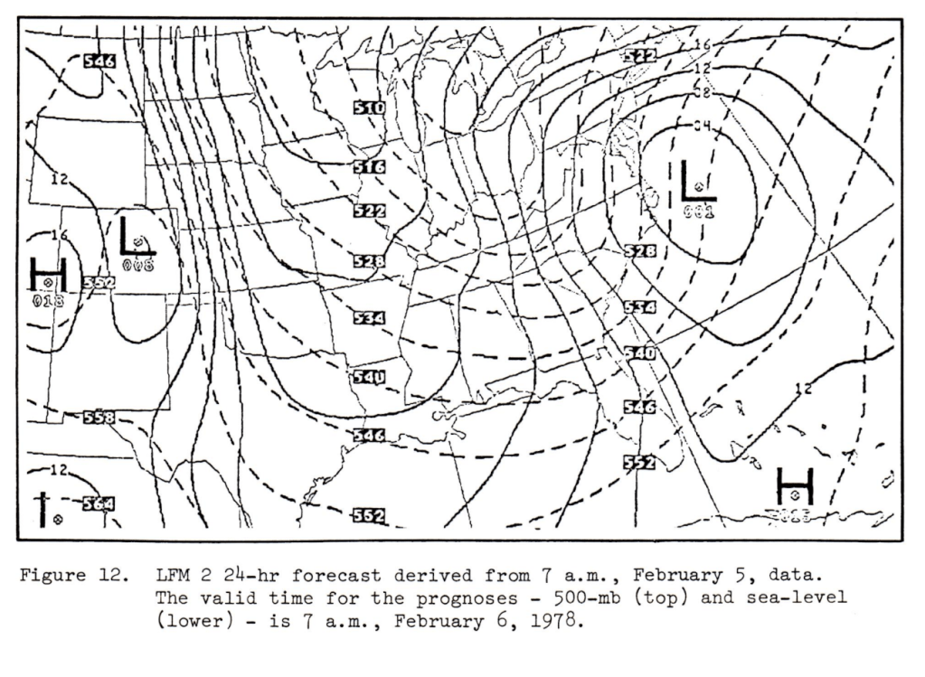
At 500 PM Sunday, February 5th, the NWS Forecast Office in Philadelphia PA issued a Winter Storm Warning for the NJ shore, indicating the potential for more than six inches of snow, with considerable blowing and drifting snow. By this time, my excitement for the storm peaked, and I could hardly wait for the snow to begin. The upgraded forecast was based primarily on the model output from the LFM, which forecast the storm to move to a position off the New England coast Tuesday morning, February 7th.
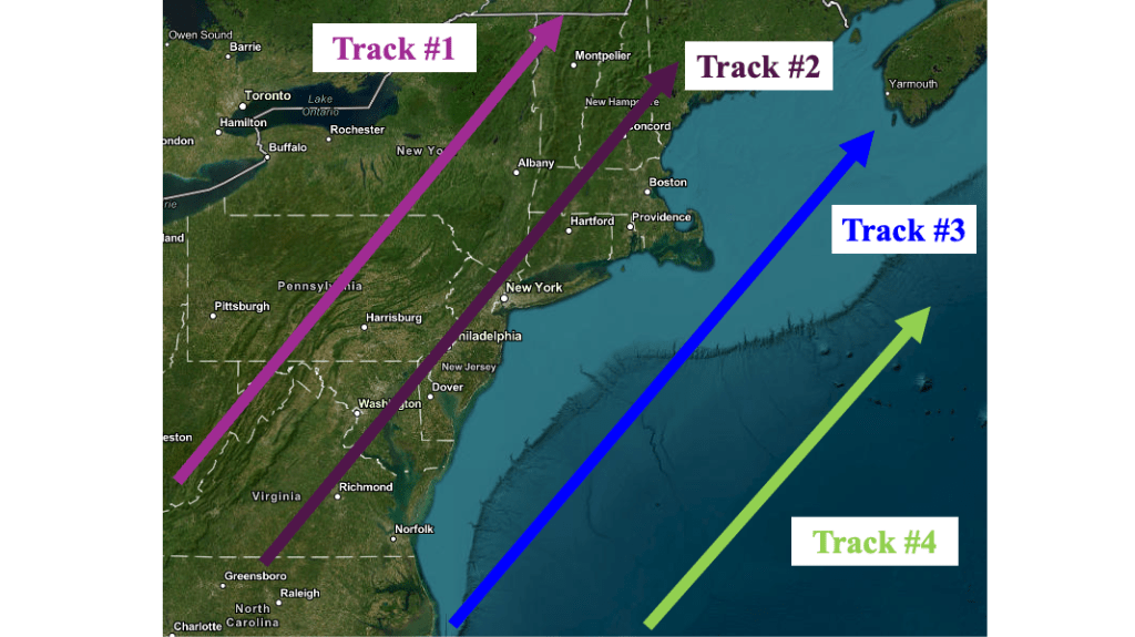
Looking at that track now (I did not have access to these graphics in 1978), it is clear that the LFM was forecasting a track that was ideal for heavy snowfall on the NJ coast. As a young forecaster, I was introduced to the conceptual model that showed common storm tracks and their propensity to produce heavy snow along the Jersey Shore. The LFM forecast was placing the storm on Track #3, which snow lovers often refer to as the “dream track”. Though I am not certain, I do not believe forecasters at the time had access to this type of map to help them determine the ideal storm track for snow on the Jersey coast.
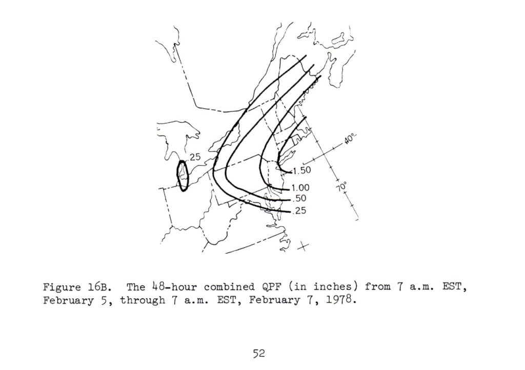
Finally, forecasters at the National Center (which would become the Weather Prediction Center) in Camp Springs, MD added some expertise to the local forecasts by indicating the possibility of 1.00/1.50 inches of liquid precipitation for the storm. Since the precipitation was expected to fall as snow for the entirety of the event, 10 to 15 inches of snow was possible with the storm Monday into Tuesday, which would be more snow than I had ever seen.
It may seem as though I have devoted a great deal of effort to outline the forecast process for this storm, but that is only because I am ASTOUNDED by how accurately this storm was forecast. Remember, this forecast was made 46 years ago with tools I would consider to be primitive now, but were nearly cutting edge at the time. In any event, the stage was set for the biggest snowstorm on the Jersey Shore for years.
The Blizzard of February 6-7 1978
Snow started falling during the early morning hours of Monday, February 6, 1978 in Toms River, NJ. In anticipation of the storm, I awoke at 530 AM, and snow was already covering ground. Temperatures were unusually cold for heavy snow, as they had dropped into the teens overnight. The forecast was instrumental is closing the Toms River school system, which meant we had all day to play in the snow. As the years pass, my vivid memories of that day have lost some of their sharpness, but I do retain the intensity of the experience. Years before I had decided I wanted to be a weather forecaster, and this storm cemented that decision. Winds picked up during the afternoon and evening, and blowing and drifting snow had become a concern. There was little traffic about, as most people had taken heed of the forecast and decided to shelter in place.
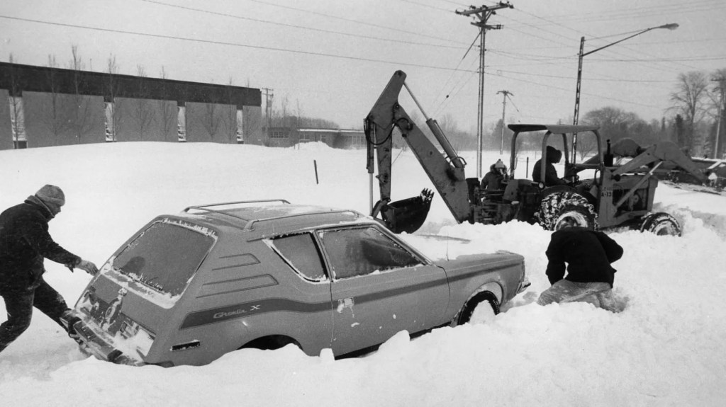
After spending practically the entire day outside in the snowstorm of my dreams, I went home. Excitement quickly faded into fatigue, and before I knew it, I had fallen asleep while the Blizzard of 1978 was still raging. To my surprise, snow was still falling Tuesday morning as I awoke. The snow ended in the afternoon, but the wind continued to produce snow drifts. Another snow day meant virtually everyone of school age was out playing in the snow. Joyfully measuring the snowfall everywhere I could indicated that 20 inches of snow had fallen during the storm, with drifts up to 5 feet against our house. My brother remembers that the tunnels we dug in the snow to get around were nearly as tall as he was.
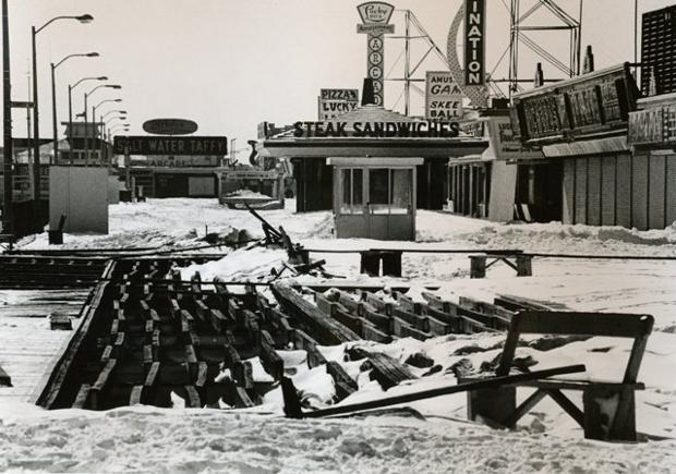
Not surprisingly, the storm produced a multitude of issues across the NJ shore and elsewhere and dominated the news for days afterward. Coastal flooding and damage done by towering seas were common all along the NJ coast, and the image at the beginning of the blog showed damage in a portion of Seaside Heights, NJ. If memory serves, we eventually were granted the entire week off as snow days (which we had to make up in the heat and humidity of mid and late June), and life only returned to normally slowly, as we dug out from the biggest snowstorm in my memory.
The Aftermath
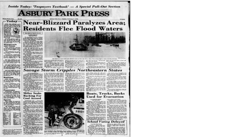
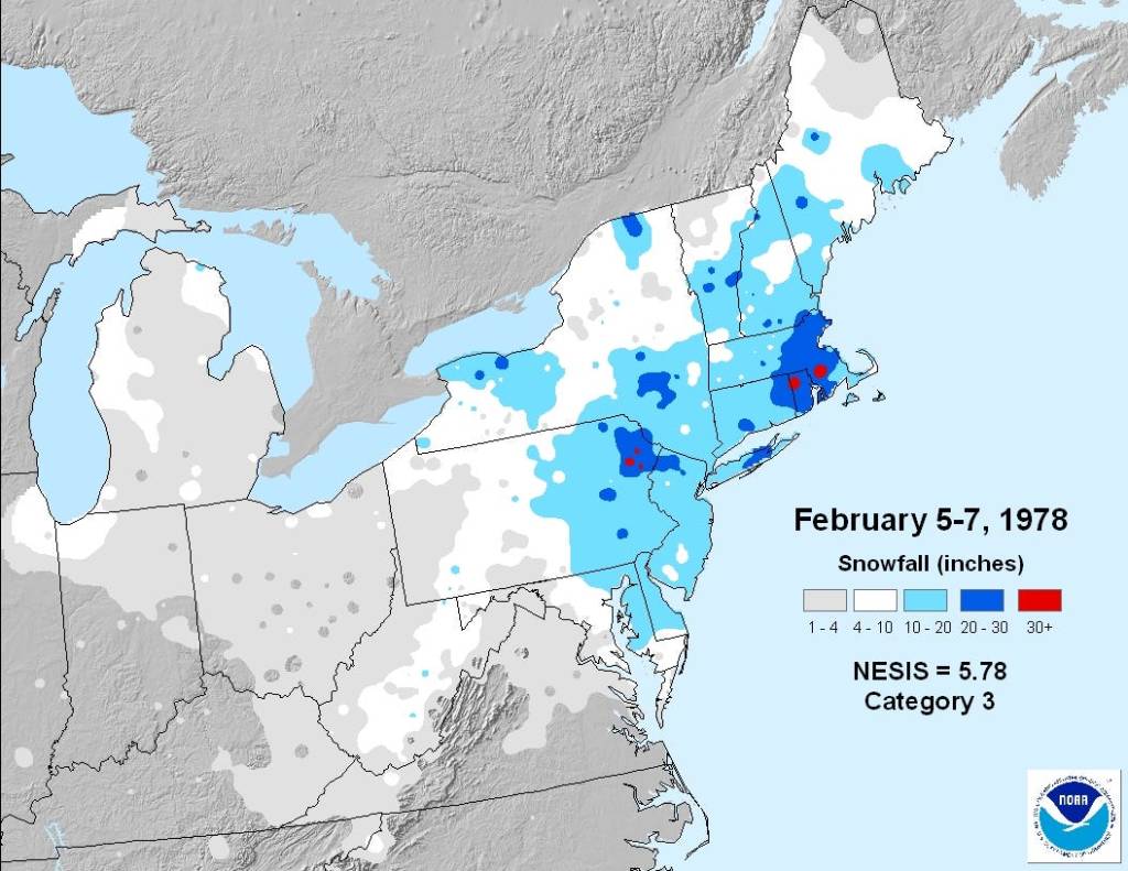
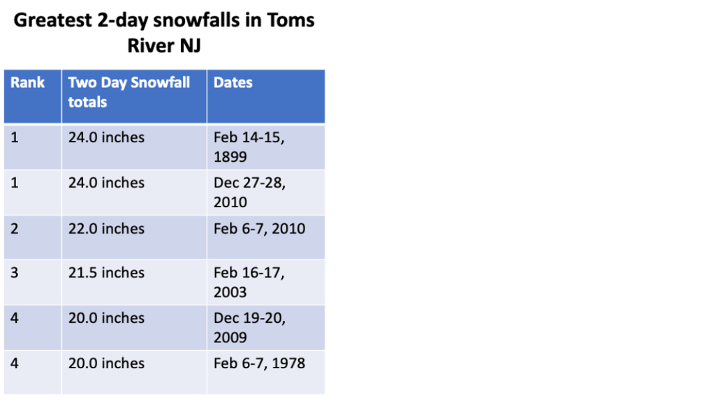
Figure 8 shows the total snowfall associated with the Blizzard of 1978. This storm is still tied as the fourth greatest two day snowfall in Toms River, NJ. Four events with greater snowfall amounts of occurred since this storm, but all of them occurred when I was elsewhere, so it still ranks as the greatest snowfall I have witnessed in Toms River.
As badly as the storm affected NJ, it reached peak intensity off the MA coast, and still represents the greatest snowfall in history in some places in RI and MA. Portions of eastern MA and RI were crippled for days after the storm, and there are many pictures that show people abandoned their vehicles Interstates to escape the wrath of the storm. In fact, the severity of the storm spurred a wave of research projects that would aid in the forecasting of strong winter storms.
The sheer power of the storm fed a burgeoning interest in weather and was instrumental in me becoming a meteorologist. There have been bigger snowstorms along the NJ coast since that event, but this one will always have a place in my heart.

Leave a comment