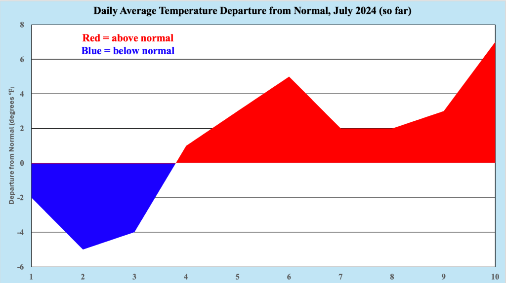
Following what might have been described as a “delightful” first three days of July 2024 (with lower temperatures and much lower humidity), heat and humidity returned with a vengeance to the Jersey Shore this week. During our current bout with summer conditions, temperatures have averaged between four and six degrees above normal, with zero high temperatures of 90 degrees or higher logged. Humidity values have been high during this time, with dew points routinely above the 70 degree mark, indicating just how muggy conditions have been along the coast.
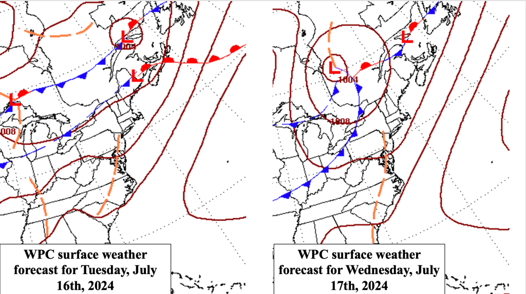
A cold front approaching the Northeast and Mid Atlantic states Friday brings with it the potential for heavy rainfall. In addition, slightly cooler and less humid conditions are expected behind the front for the beginning of the upcoming weekend. However, the respite is expected to be brief, as the next heat wave builds into the region, which continues into the middle of next week. Temperatures along the Jersey Shore could crack the 90 degree marks during next week, as the sea breeze may not be as protective as it has been this week.
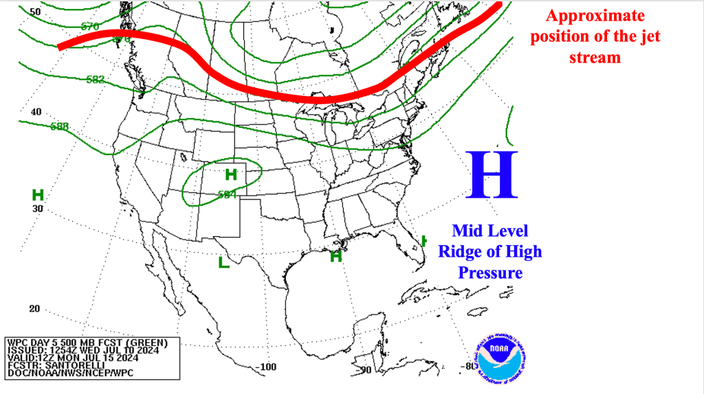
Figure 2 shows the expected positioning of the mid level features across North America early next week. Note the large mid level high pressure system (also referred to as a mid level ridge), providing an environment of sinking air to much of the East Coast, pushing the jet stream back toward the US/Canada border. At the surface, high pressure anchored off the Mid Atlantic Coast (known as a Bermuda High) brings a broad southwest flow of hot and humid air to the East Coast as well, locking in the heat into the middle of next week. Unlike this past encounter with heat and humidity, the Jersey Shore may see temperatures warmer next week than this week, as the sea breeze may be less likely to have significant effects on high tempeatures.
The nearly ideal positioning of high pressure at the surface and the mid levels offers the real possibility of temperatures well into the 90s, especially away from the immediate coast. Along the Jersey Shore, as the surface high strengthens, it should create an opposing flow strong enough to keep the sea breeze at bay, with high temperatures approaching or even exceeding 90 degrees on Monday, Tuesday and Wednesday (which would constitute a heat wave, defined as three consecutive days with high temperatures of 90 degrees or above). Regardless of whether the Jersey Shore sees highs in the 90s or not, summer temperatures make a strong return to the region.
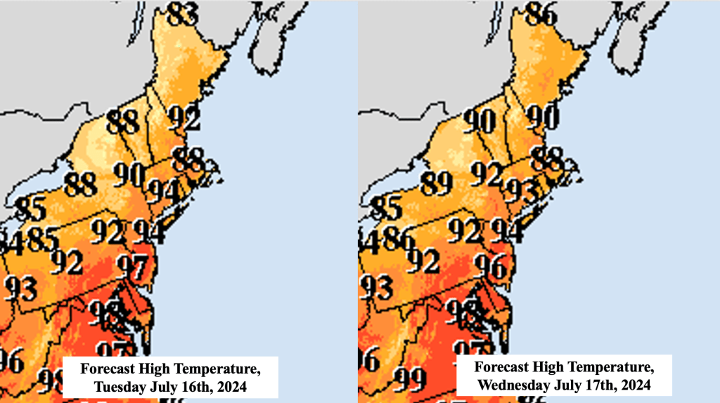
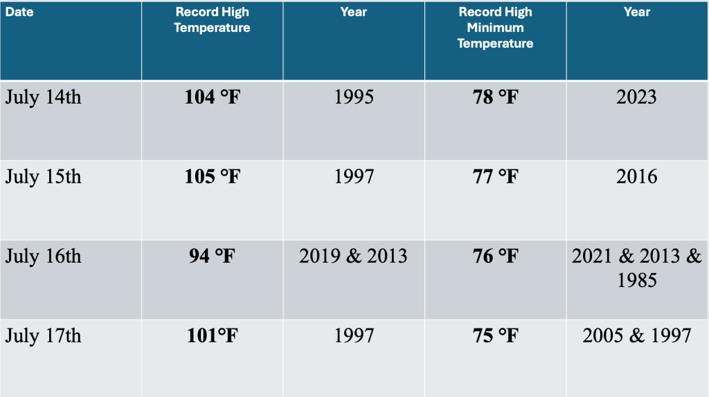
As we approach the hottest part of the summer on the Jersey Shore (when the average high temperature flirts with the 90 degree mark), it becomes increasingly unlikely we will set any new daily record high temperatures with the next wave of heat. The best chance might be Tuesday, July 16th, as the record high that day is 94 degrees, which could be reachable, particularly if the sea breeze does not interfere with heating. Otherwise, record high temperatures are above 100 degrees, and these values seem to be out of reach.
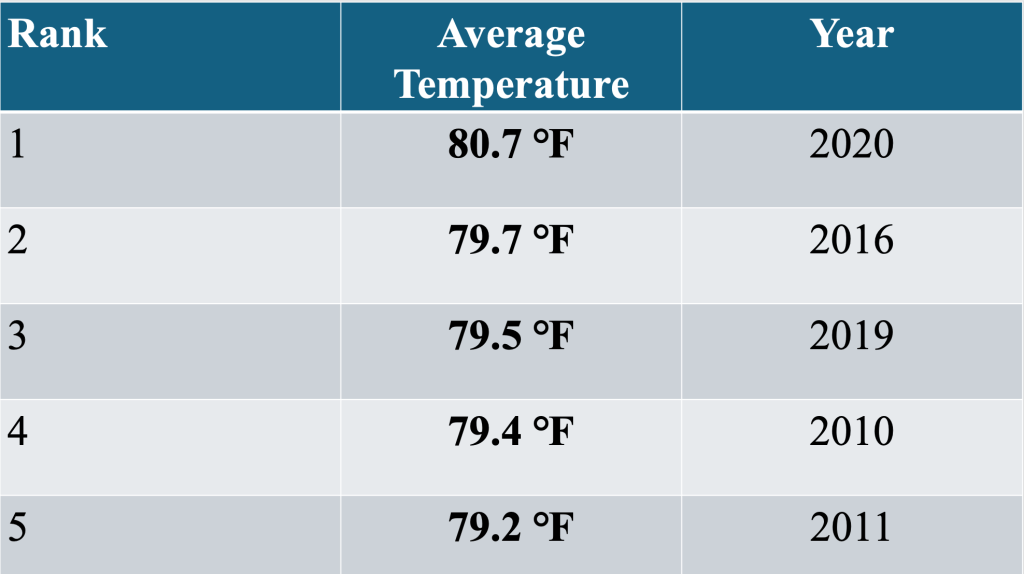
While the average monthly temperature for July 2024 is fairly close to normal (due in large part to the cool start), the combination of the current heat wave and the approaching heat wave could boost that value considerably by this time next week. The warmest July on record occurred in 2020, with a monthly average of 80.7 degrees, the only month with an average temperature that high at our location. That value seems out of reach, but depending on how warm next week becomes, a top five warmest July is possible.

Leave a comment