Rounds of showers and thunderstorms Sunday night into early Monday morning pushed the heat and humidity out into the Atlantic Ocean, replaced by an airmass that could be described as delightful for late June along the Jersey Shore. The high temperature in the Bellcrest section of Toms River, NJ topped out at 83 degrees on Monday, a whopping 13 degrees lower than Sunday, and close to the normal high for June 24th (82 degrees). Alas, the cooldown will be brief, as warmer and more humid air returns to the Jersey Shore Tuesday into Wednesday, ahead of a cold front that brings slightly cooler air to the region for the end of the week
High temperatures Tuesday may stop short of the 90 degree mark, especially along the coast, should the west wind become onshore during the afternoon. Wednesday looks to be the warmest day of the week, as a freshening southwest winds ahead of an approaching transports temperatures in the lower to mid 90s across the Mid Atlantic and Northeast states. In this scenario, a sea breeze is not expected to develop as the opposing wind flow looks to be too strong, and temperatures along the coast may be nearly as warm as further inland.
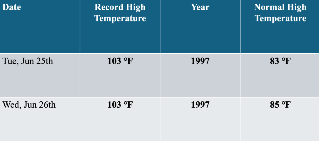
Though high temperatures in the 90s is still above normal for the region, the high temperatures on Tuesday and Wednesday are expected to remain well below record levels. Record high temperatures each day (103 F) are about as high as they can get for late June, and should be well above the high temperatures expected during the mid week.
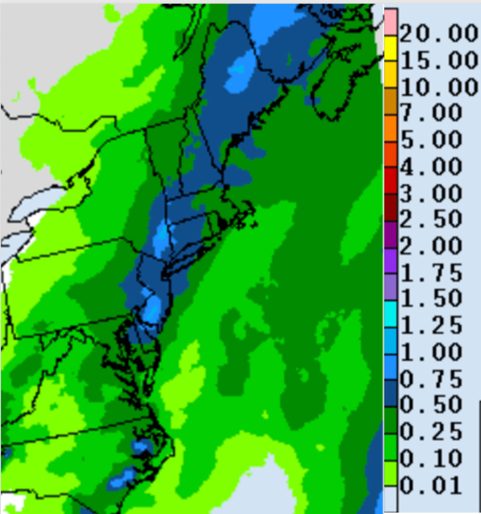
Ahead of the front, deeper moisture funneled into the region is expected to support thunderstorm development, which likely peaks Wednesday afternoon into late Wednesday evening. Rainfall amounts could top an inch for portions of the Jersey Shore during that time frame, as clusters of storms track over the region. Thus far during June 2024, rainfall has been fairly scarce, and the rainfall that occurred Sunday night was the first measurable rainfall in the Bellcrest section of Toms River, NJ since June 6th, a span of 16 consecutive days without rain.
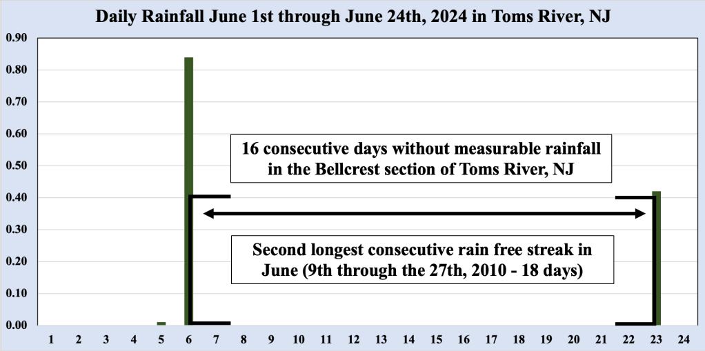
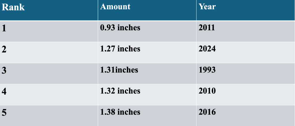
This was the second longest rainfree streak in June at this location, bested only by the 18 day streak occurring in 2010. So far, 1.27 inches of rain has been recorded by our station in June, which represents the second driest June on record for this location (the driest June happened in 2011, when a scant 0.93 inches of rainfall was logged). However, rainfall ahead of the cold front Wednesday afternoon into Wednesday night could knock June 2024 out of the top five driest Junes on record.
Rainfall amounts with the storms Wednesday into Wednesday night would be more than enough to displace June 2024 from the top five driest months of June here. Even if heavy rainfall materializes, the additional rain would not even result in us catching back up to normal for June, as the normal rainfall is 3.71 inches. Cooler weather is expected for the balance of the week behind the cold front, but southwest winds ahead of yet another front Saturday could allow temperatures to once again to jump into the lower 90s before falling back close to normal to close out next weekend.

Leave a comment