During the the heat wave that has been affecting the East Coast during the past week, the general surface wind flow has been from the southwest, maintaining the heat and humidity. However, closer to the coast, especially east of the Garden State Parkway in NJ, the local wind flow has been south to southeast, reflective of the developing sea breeze each afternoon this week. The sea breeze kept temperatures cooler along the Jersey Shore, particularly earlier in the week.
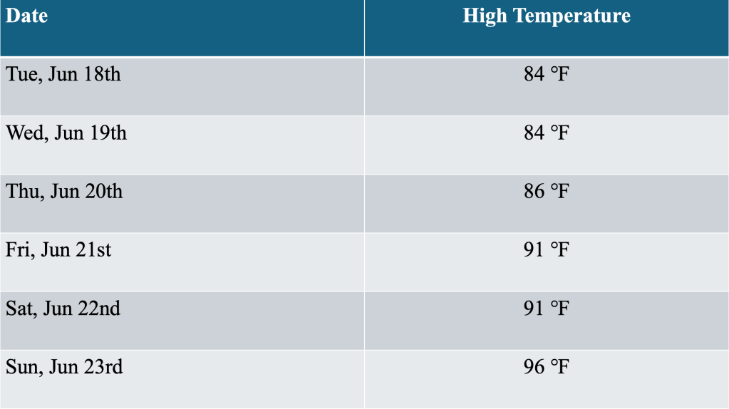
However, as the airmass warmed from within (which often happens with large areas of high pressure along the East Coast during the summer), the sea breeze developed later in the day, and did not penetrate as far inland by the weekend. This allowed temperatures along the shore to touch the 90 degree mark Friday, Saturday and Sunday. High temperatures in the Bellcrest section of Toms River, NJ, reached or exceeded 90 degrees each of the abovementioned days, meeting the criteria for a heat wave (high temperatures of 90 degrees or above for at least three consecutive days).
The southwest flow that has affected the region increased this morning as a cold front approached from the Ohio Valley. The slight increase in flow was enough to keep the sea breeze at bay, at least for a little while, in the Bellcrest section of Toms River, NJ during Sunday, June 23rd. After a low temperature of 76 degrees (the normal low for this location on June 23rd is 64 degrees), temperatures rose steadily through the late morning, reaching a peak shortly after noon.
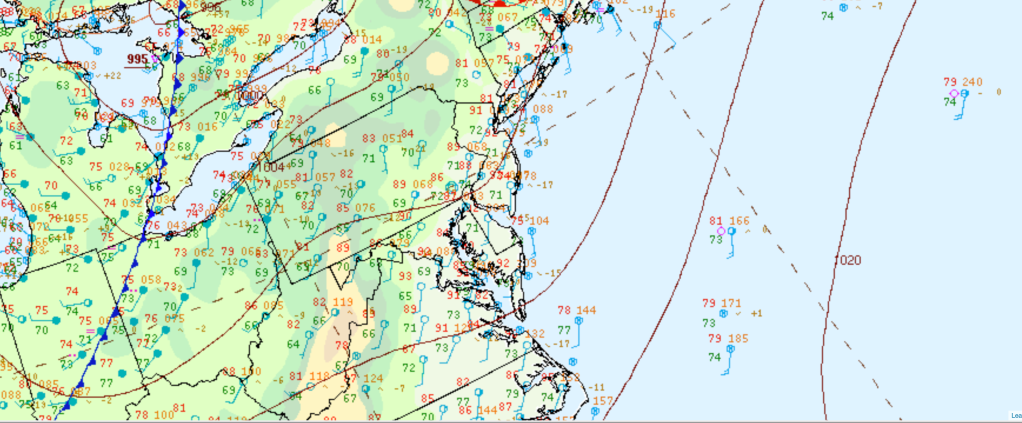
Figure 1 NOAA’s Weather Prediction Center’s surface analysis valid at 1100 EDT, Sunday, June 23rd, 2924.
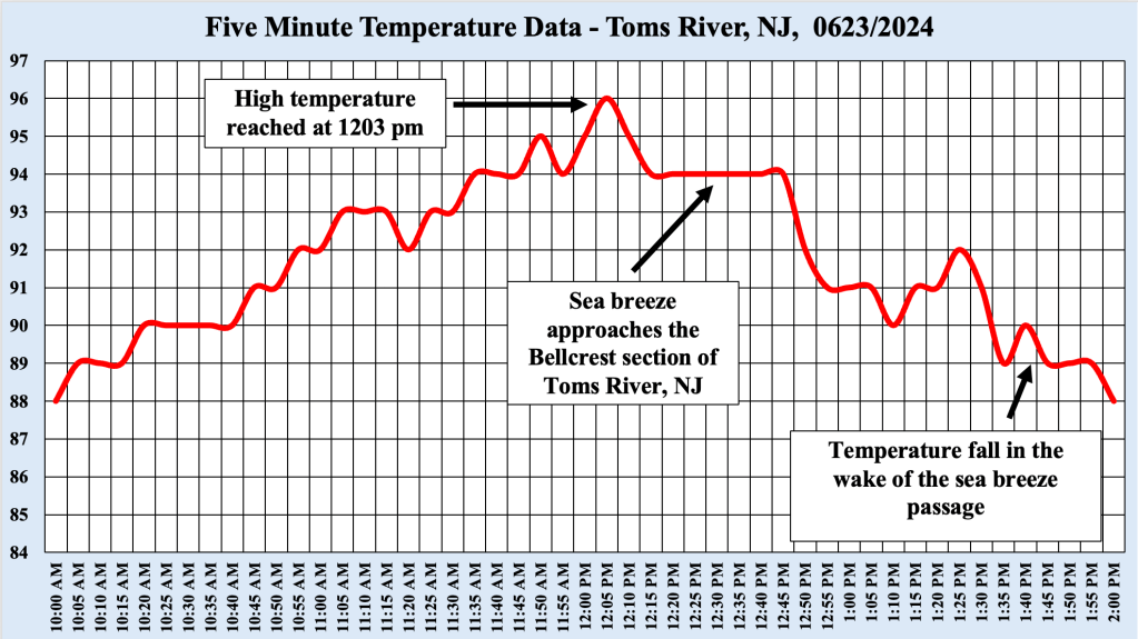
At 1203 PM, the temperature in Toms River reached 96 degrees, which set a new daily record high temperature for that location (the previous record was 95 degrees set 2015 and 2010). Soon after, the sea breeze began to reassert itself, marching into the Bellcrest section of Toms River, pushing temperatures back down into the upper 80s, which is more in line with high temperatures there is week when the sea breeze was the primary controlling factor for high temperatures.
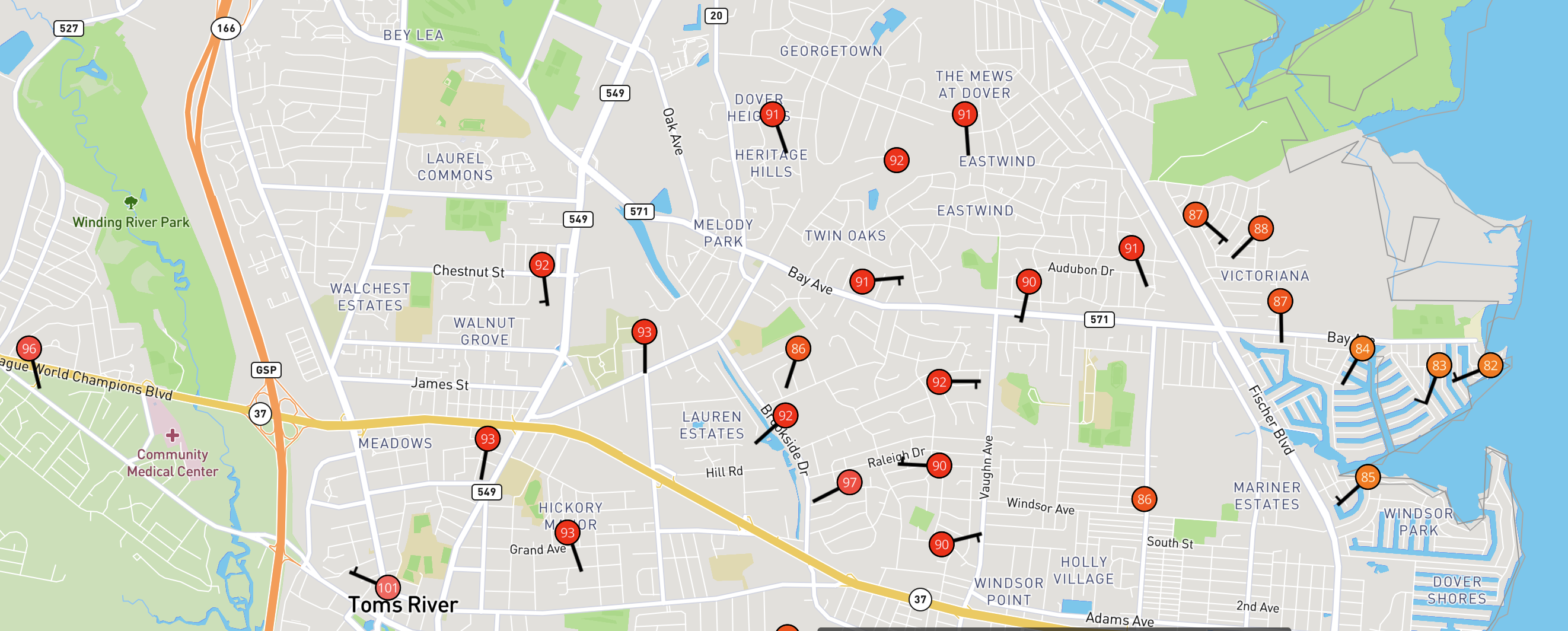
Based on surface observations around the region, the sea breeze made it about as far west as Toms River, as temperatures west of the area were firmly entrenched in the mid to upper 90s, while temperatures slid back into the 80s where the sea breeze passed. It is possible with the approach of the cold front that the winds may shift back to the southwest, and the sea breeze could be kicked back into Barnegat Bay, which would allow temperature near the coast to warm once again. In any event, the temperature plot from our weather station, as well as the maps from the region, showed that the sea breeze was only partially successful in keeping the Jersey Shore cooler this afternoon.

Leave a comment