Overview
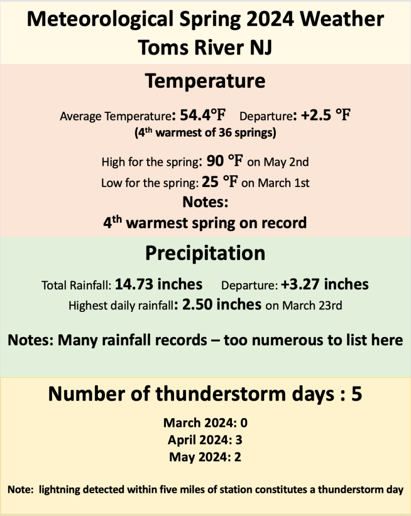
Meteorologists consider spring to stretch from March 1st to May 31st, inclusive. This is done primarily to make calculations of parameters simpler and more consistent (as the first day of each season can vary slightly, resulting in difficulties comparing seasonal averages). Typically, the coolest month of the winter is March, which is just shaking off the affects of winter, and the warmest is May, with the advent of summer arriving. Meteorological spring bridges the gap between winter and summer, and that was again the case in 2024, though the first half of spring 2024 was among the wettest at this station. Overall, temperatures were warmer than average, peaking in March before sliding back toward normal for April and May.
Rainfall
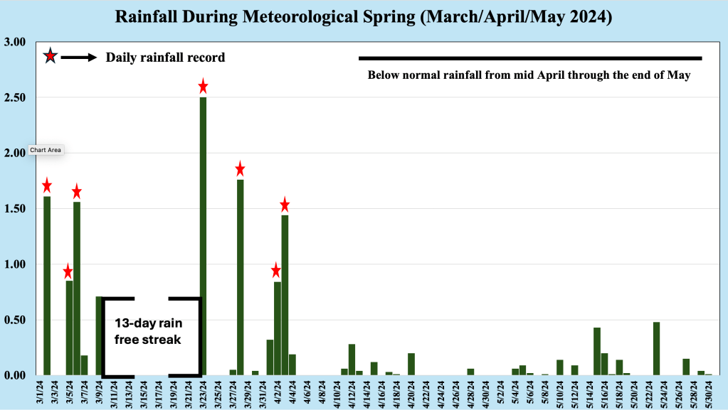
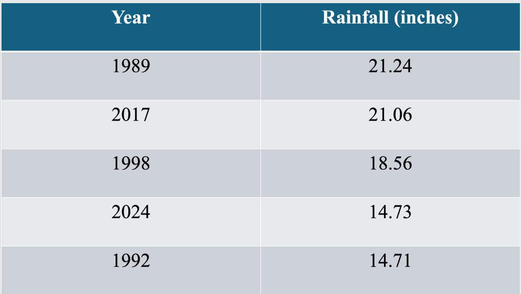
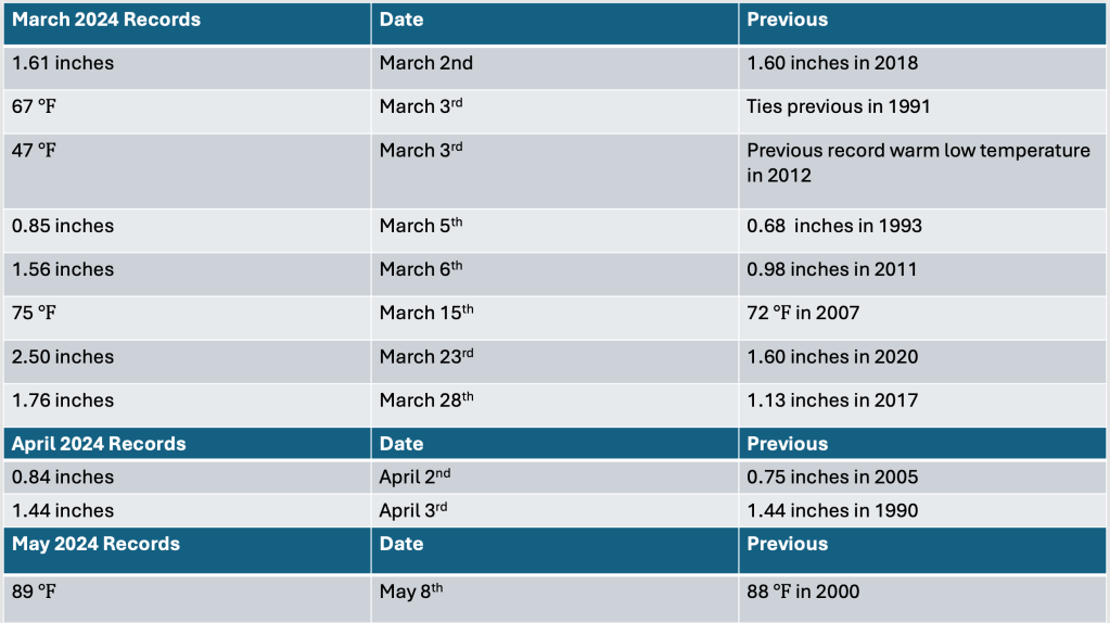
As was the case during meteorological winter (December 2023/January 2024/February 2024), the first third of the meteorological spring 2024 was much wetter than normal. March 2024 was the wettest March on record for the location, and it marked the first time rainfall during March topped 9.00 inches. Curiously, after setting three daily record rainfall marks, the atmosphere dried out, producing a 13 day streak of no rainfall, the third longest such streak in March. The atmosphere remained active after the break, when four new daily rainfall records were set in late March and early April. The combination of deeper moisture around high pressure to the south and a winter like progression of storms led to the record rainfall.
A quickly changing pattern from mid April through the end of May kept rainfall amounts relatively light, and no additional rainfall records were set during this period. Though rainfall amounts were below normal for May, we logged 15 days of rainfall during the month, or rainfall every other day. Typically, rain falls 11 days during the month, and despite more rainfall events, May 2024 remained below normal for total rainfall. This was again due to the fact the most system were fast moving, unable to tap deeper moisture for heavier rainfall.
Temperature
March 2024 was the third warmest March on record for our station, averaging over five degrees above the long term normal! That was true despite the fact that the end of March 2024 was actually a bit cooler than normal, as the atmosphere reminded Jersey Shore residents that the end of March can still be winter here. However, even the coldest part of the month did not yield any snow, and no portion of the NJ coast measured any snow during March 2024. Two daily record high temperatures were established during month, as was a record warm minimum, a testament of the early March warmth.
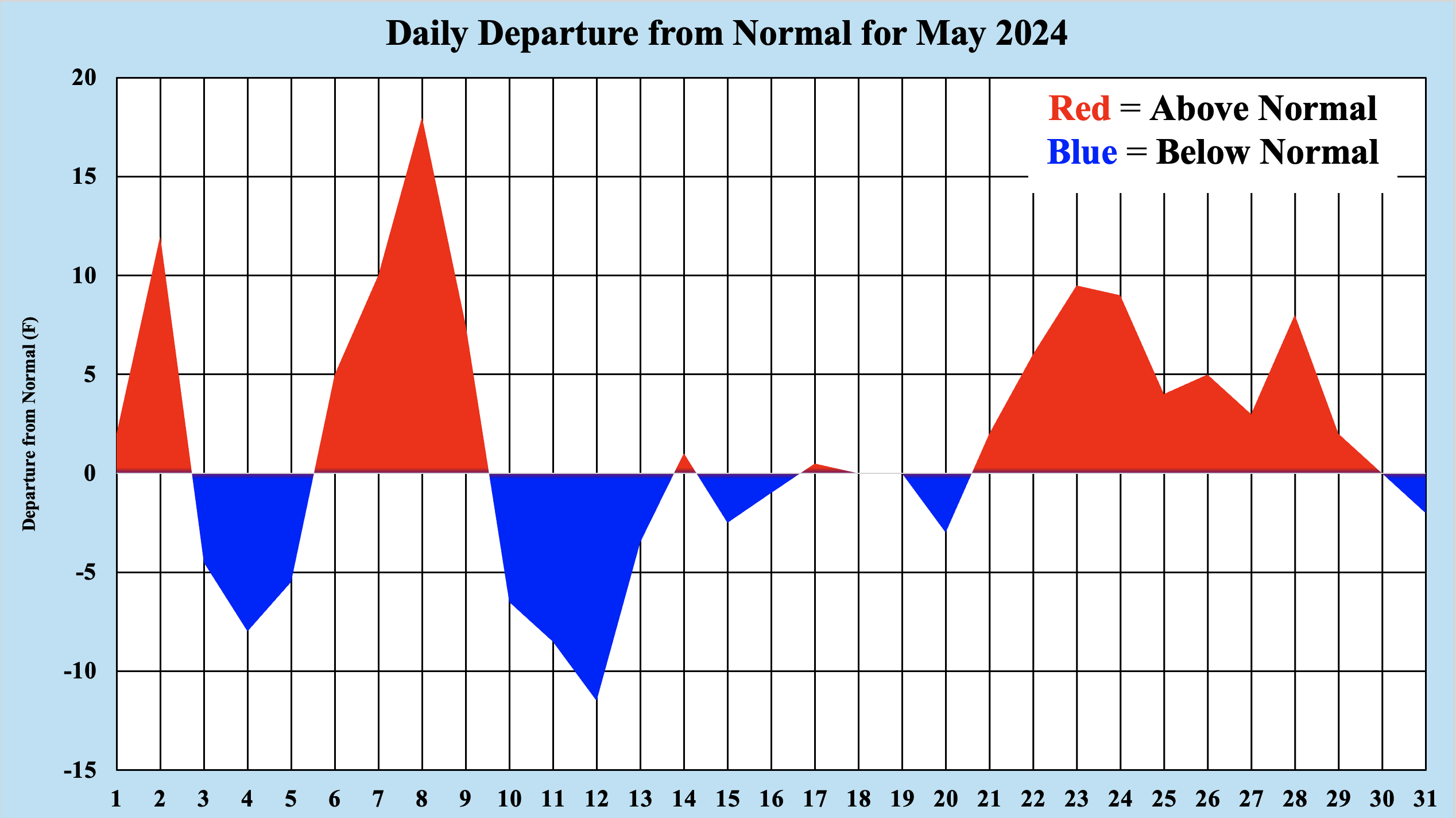
While temperatures averaged above normal during April and May 2024, neither month was much more than one and one-half degrees above normal. As might be expected during the transition season of spring along the shore, temperatures alternated between above normal and below normal. When winds were offshore, temperatures averaged above normal, as southwest winds brought warmer temperatures to the Jersey Shore from the Mid Atlantic states. Winds from the still cool Atlantic brought temperatures below normal, and this tug of war lasted throughout the remainder of spring.
Only one daily record high temperature was established during this time, when temperatures reached 89 degrees on May 8th 2024, just nudging out the previous record of 88 set back in 2000. May 2024 also brought the first 90 degree temperature of 2024 to the Jersey Shore, when our station logged a high temperature of 90 degrees on May 2nd. Normally our first 90 degree occurs closer to Memorial Day.
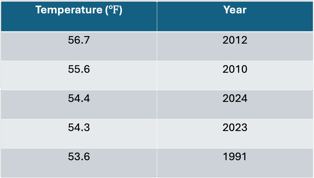
Overall, spring 2024 was the fourth warmest spring on record at this location, impressive because almost all of this warmth occurred during March 2024, not May 2024 as might be expected. In fact, the most rainfall and warmth occurred in March, as if the spring roared in like a lion and limped out as a mouse.
Thunderstorms
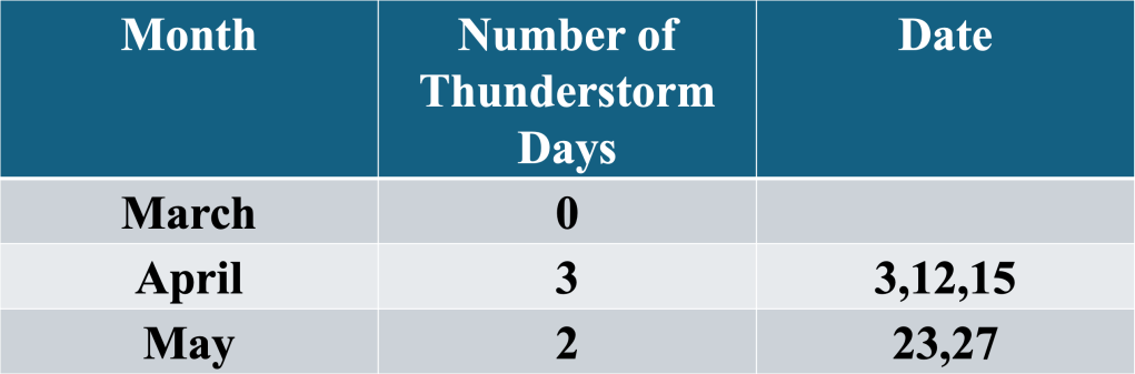
Table 5 Number of thunderstorms dates, by month, during the meteorological spring 2024 along the Jersey Shore
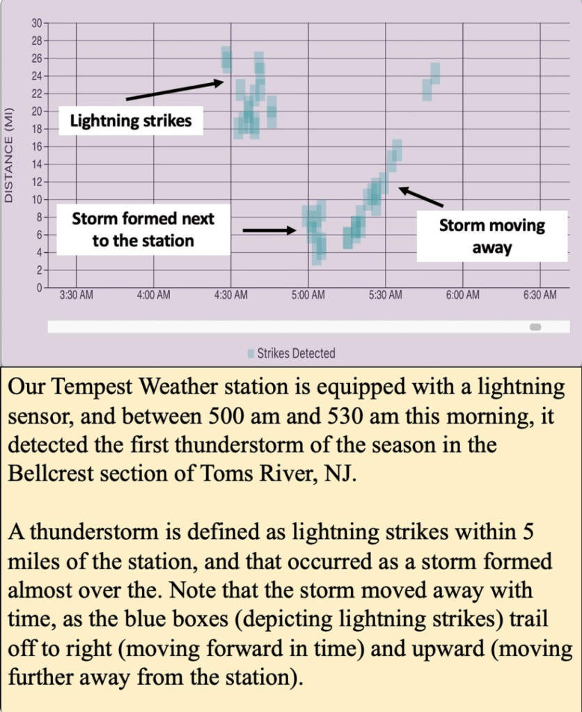
Following the six month stretch of no thunderstorms reported by our station, the first thunderstorm of the year was detected during the early morning hours of April 2nd 2024! For our purposes, a thunderstorm is defined as lightning strikes with 5 miles of our Tempest Weather station, which can detect lightning strikes up to 25 miles away. During this event, storms formed almost directly over the station before moving over the ocean and dissipating. We have seen as many as 3000 lightning strikes in a three hour period of storms last summer.
There were only two thunderstorm days logged during May 2024, toward the end of the month as the transition from winterlike rainfall to thunderstorm driven rainfall continued.

Leave a comment