Jersey Shore residents and visitors alike are quite familiar with the sea breeze, which seems like a constant companion that arrives in May and departures during September. When the sea breeze develops, it can result in temperatures dropping considerably along the coast during the afternoon, especially compared to places further inland. On rare occasions, the sea breeze can serve as a boundary upon which thunderstorms can develop, but much more often the sea breeze brings with it a change in wind direction and drop into temperature.
What is a Sea Breeze?
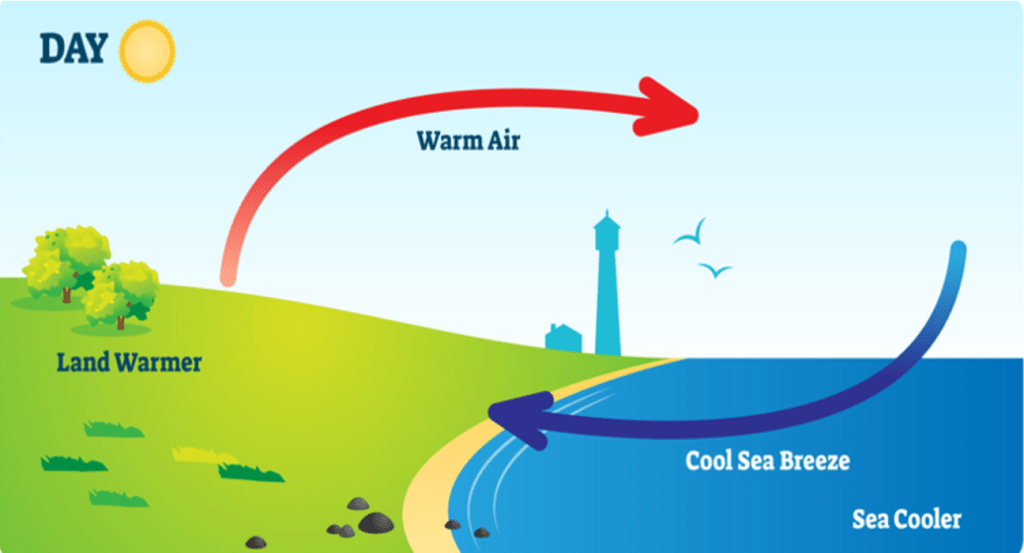
Generally, a sea breeze is defined as a wind that blows from the sea to the land during the day, due mainly to the relative warmth of the land. However, the sea breeze is more dynamic than that. During the day, the land surface heats up faster than the water surface, as water is much denser than land, and requires much more energy to warm, especially in the spring. The warmer air over the land tends to rise, air from the ocean flows inland to replace the air that has risen.
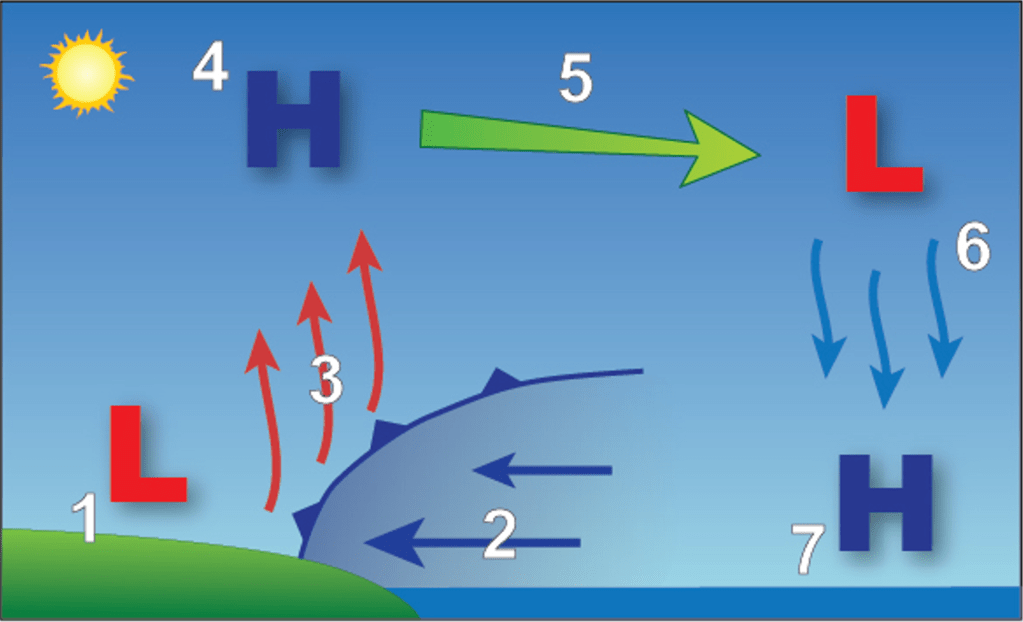
Once the rising air over land becomes the same temperature as its surroundings, it ceases rising, and it transported back over the ocean above the surface (step 5 in Figure 2). Eventually, the air that arrives over the ocean sinks because it is cooler than its surroundings, and returns to the ocean’s surface (step 6). Though this model does show what occurs when the sea breeze circulation develops, a sea breeze is not guaranteed. If the surface wind is from the southwest to northwest AND is faster than about 5 to 10 mph, the sea breeze may still develop, but its circulation will likely remain offshore. Known as the opposing flow, the west wind can keep the sea breeze from affecting land areas. However, this concept is well known to forecasters and residents alike, and is taken into consideration when forecasting whether the sea breeze will make it inland during the day.
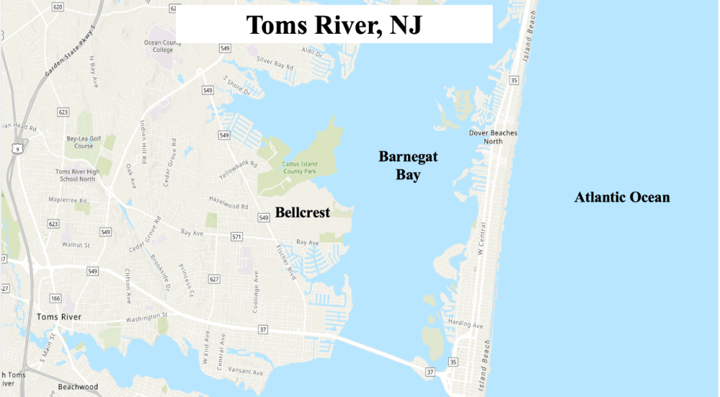
When the large scale flow across the eastern US is relatively weak (as it is during much of the summer along the Jersey Shore), sea breezes can form on consecutive days, unfolding more or less the same each day, right down to the timing of the sea breeze as it crosses the coast. When we discuss the sea breeze along the Jersey Shore, we mostly discuss it from the point of view of our weather station, which is located in the Bellcrest section of Toms River, NJ. Located less than three and one-half miles from the Atlantic Ocean along the central NJ shore, our station is often affected by the sea breeze, and occasionally is near the interaction of the sea breeze with a local bay breeze, which can result in a large difference in temperatures over a short distance.
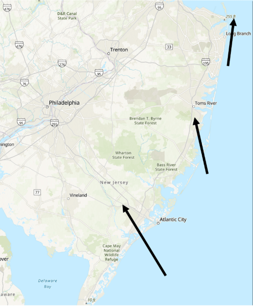
Where you are along the Jersey Shore does affect how you experience the sea breeze. Across southern NJ, the sea breeze is a southeast wind in places like Atlantic City. Closer to Toms River, the sea breeze is a south wind, and near Sandy Hook the sea breeze is a southwest wind. The change is wind direction nearly mirrors how the coastline changes from southwest to northeast, and it is though that the change in coastline changes the sea breeze direction due to something called low level convergence, which is beyond the scope of this blog entry.
How Does the Sea Breeze Affect the Weather at the Jersey Shore?
For the most part, the greatest impact of the sea breeze on the Jersey Shore is to keep the immediate coast (generally east of the Garden State Parkway cooler, along with a stronger breeze than further inland. Once the opposing flow is overcome and the sea breeze develops, the strength of the sea breeze is predicated on the temperature difference between the ocean and points further inland. Years ago, statistical relationships between the difference between inland points and the ocean temperature were used to determine the wind speed expected with the sea breeze. Modern computer models are quite adept at forecasting these winds speeds accurately, and have largely replaced the statistical relationships.
As might be expected, when the temperature difference between the ocean and points further inland are greater, winds speeds associated with the sea breeze are stronger and penetrate further inland. During the summer, when the temperatures differences are not as great, the sea breeze winds speeds are less, and the breeze itself may not reach as far inland.
Another effect of the sea breeze has on the Jersey Shore is to clear out cloudiness. Sea breezes can clear out clouds by causing air to sink (because it can no longer support cloud development due to lack of instability), where it compresses, warms, and evaporates the cloud moisture. For example, during a typical summer day in NJ, as the sea breeze passes locations, the clouds dissipate, but clouds away from the influence of the sea breeze remain (where instability remains abundant enough to support cloud development).
Typically, sea breeze circulations are so shallow (less than a couple of hundred meters) that they do not often serve as boundaries for thunderstorms at the Jersey Shore. In other parts of the world, particularly where sea breeze collide, convection can develop and become quite intense. That is generally not the case on the Jersey Shore, but it has happened as recently as 2022. The intersection of a sea breeze and a local front in central NJ provided enough lift to support thunderstorms in portions of western and northern Ocean County on August 5th, 2022. The stationary storms produced nearly a foot of rain in these locations, causing flash flooding which required water rescues.

A Review of Sea Breezes Interacing with Local Boundaries near Toms River, NJ
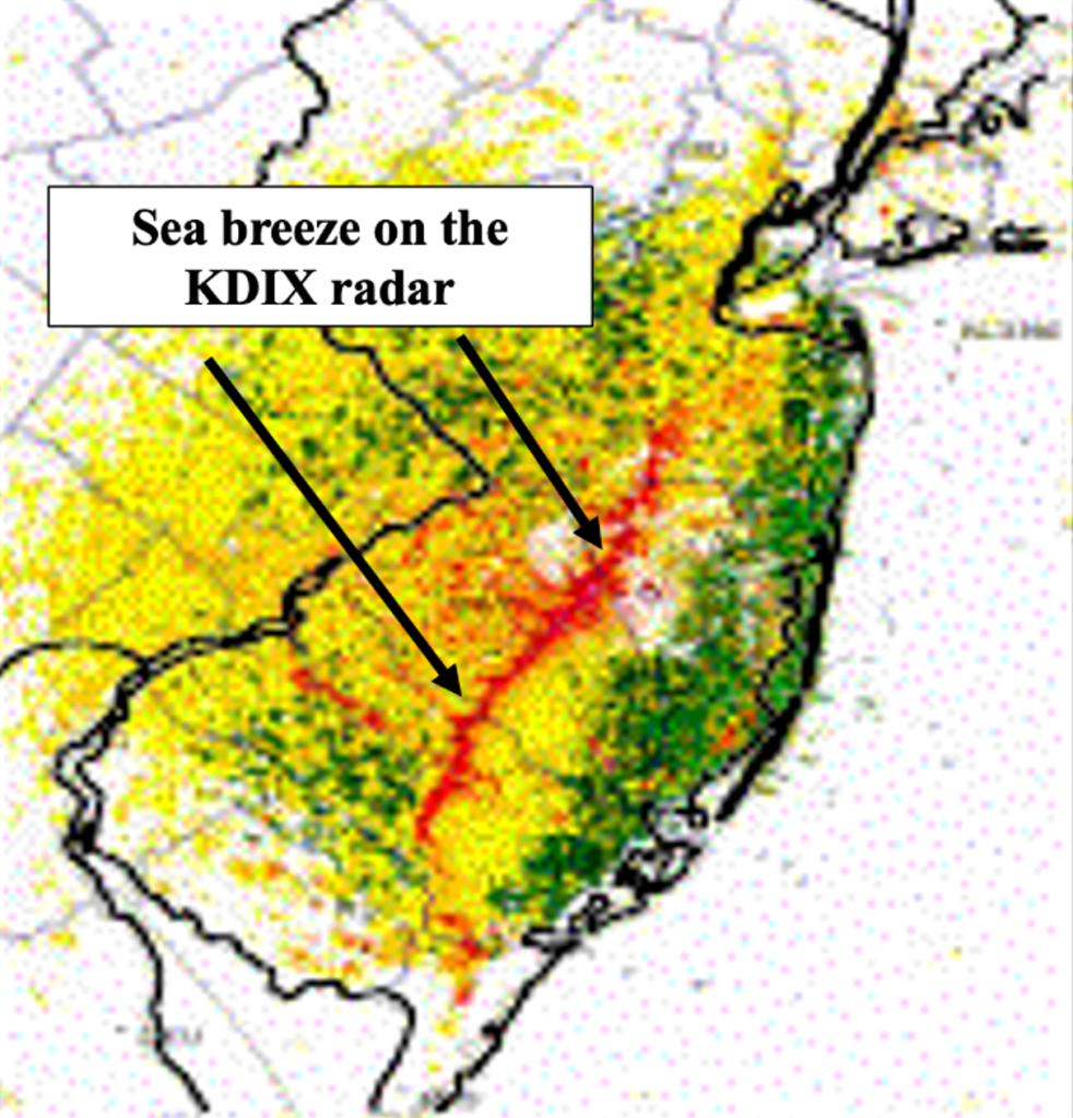
The advent of personal weather stations and websites from which to view them (such as Weather Underground), small scale weather phenomenon have become much easier to detect and forecast. Using weather information from Weather Underground, as well as our own weather stations, we were able watch the interaction of a sea breeze and local boundaries (such as weak fronts or breezes generated by Barnegat Bay). There was not much in the way of sensible weather with these interactions (meaning there was no storms or rain with the interaction), but the temperature swings were impressive at our weather station, to say the least.
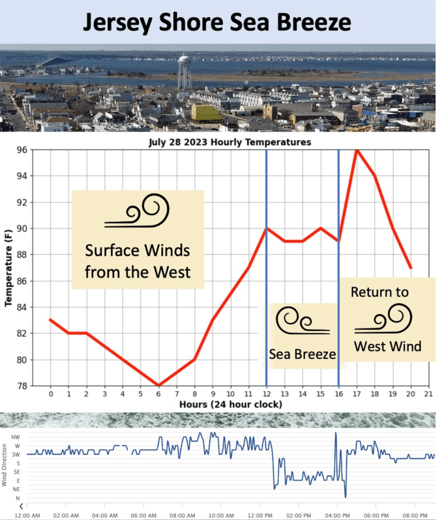
The first such event captured occurred on July 28th, 2023. A westerly surface wind had developed (which is typical during the morning hours in the Bellcrest section of Toms River). Note that temperatures (depicted in red) rose steadily between 6 am and noon local, as temperatures topped out at 90 degrees by noon. However, an unusually strong sea breeze (augmented by a Barnegat Bay breeze) pushed westward across Toms River, dropping the temperature at our station back down into the upper 80s for a couple of hours. Typically, once the sea breeze develops, temperatures stop rising, and even fall a bit as the influence of the ocean increases. The image shows precisely that, as temperatures hovered just below 90 degrees between noon and 4 pm.
The land breeze was simply too strong, though, and it pushed back against the sea breeze, retaking Toms River in the process. Once the westerly wind commenced over our weather station, temperatures jumped 7 degrees between 4 pm and 5 pm, topping out at 96 degrees. We narrowly missed setting a new daily high temperature record for the day, which is 98 degrees set in 2020.
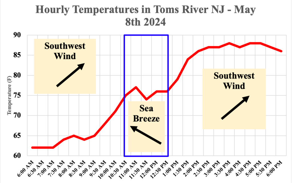
Our second example occurred earlier this month. During this event, a sea breeze was enhanced by a backdoor cold front (a cold front that moves from east to west, rather than west to east). Much like the first event, temperatures rose steadily at our station during the morning hours, leveling off in the early afternoon as the sea breeze passed. However, the effect of the sea breeze and backdoor front were limited, and the stronger westerly flow won out, kicking the cooler air back across Barnegat Bay. Temperatures rose an additional 10 to 15 degrees after the sea breeze left, allowing the high temperature that day in Toms River to reach 89 degrees, which did set a new daily high temperature record for the date.
Review
The sea breeze along the Jersey Shore is typical of sea breezes that develop around the world, as cooler air from the body of water moves island to replace the warmer air that rises across inland locations. The main weather change that occurs with the Jersey Shore sea breeze is that temperatures tend to be appreciably cooler near the coast (east of the Garden State Parkway), and can occasionally result in a large temperature difference between the beaches and inland areas, particularly during the spring, when wind speeds tend to be their highest with sea breezes.
Clouds that develop near the coast before the sea breeze moves inland dissipate once it has crossed, as the instability is no longer sufficient behind the sea breeze to support additional clouds. Thunderstorm development on the sea breeze itself near the Jersey Shore is fairly rare, as the airmass is too stable to support the activity.

Leave a comment