Not too surprisingly, May 2024 has debuted as cooler than normal with nearly half of the days of the month having rain, yet rainfall amounts are below normal so far. May along the Jersey Shore can often contain two distinct personalities, each reflecting the exiting season (early spring) and the approaching season (late spring/early summer). May 2024 seems to be echoing this pattern thus far, with hot temperatures, near record low temperatures, and mostly light rainfall that seems to favor weekends.
Temperatures
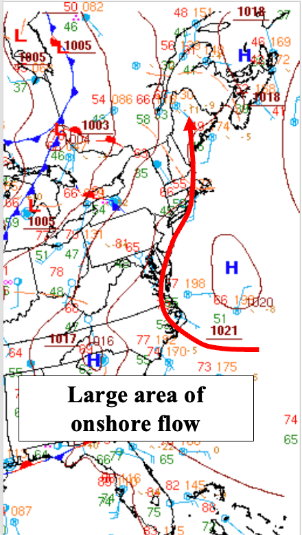
NOAA’s Weather Prediction Center’s (WPC) surface analysis valid for late this afternoon, Monday, May 13th, showed a broad area of high pressure centered just off the US East coast. The clockwise flow around the high brings air from the ocean across the East, particularly east of the Appalachians Mountains. Air temperatures off the coast generally average in the upper 40s to mid 50s, which becomes the de facto high temperatures for coastal areas from the Mid Atlantic states into New England. For reference, the normal high for May 13th in the Bellcrest section of Toms River, NJ is 67 degrees.
Low temperatures this morning (Monday, May 13th 2024) were generally in the mid 30s to lower 40s across the Jersey Shore, which is about 10 to 15 degrees below normal for the date. The low temperature this morning for our station was 41 degrees, which was only three degrees above the daily record low temperature for May 13th, which is 38 set just four years ago in 2020.
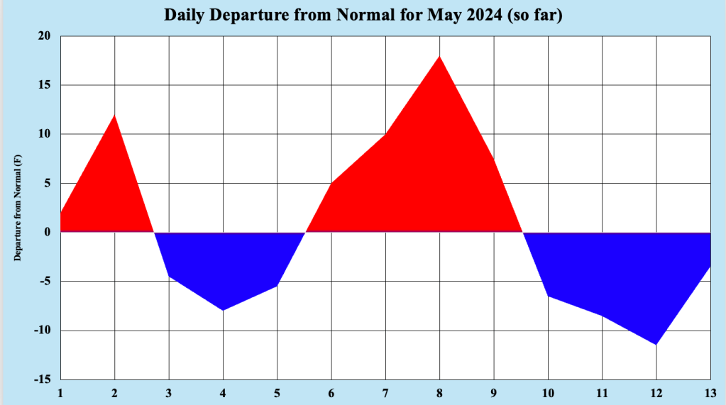
By contrast, bursts of much warmer than normal temperatures affected the Jersey Shore as well this month, with our station reaching 90 degrees for the first time on May 2nd (the normal date for our first 90 degree is May 27th). The high temperature in Toms River just missed reaching 90 degrees again on May 8th (with high of 89 degrees), which was warm enough to establish a daily record high for the date. Figure 2 is a testament to the roller coaster temperatures the Jersey Shore has seen so far this month. In general, the warmer May days were associated with an offshore flow, and the cooler days occurred when the flow was onshore.
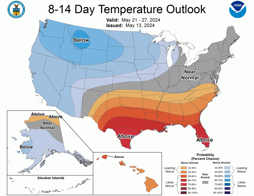
So what does this mean for the rest of May 2024 along the Jersey Shore? Figure 3 shows the Climate Prediction Center’s (CPC) latest 8-14 Day Temperature Outlook valid May 21 – 27 2024, which shows near normal temperatures should continue through Memorial Day 2024. The weather pattern across the US remains fast for mid May, suggesting that weather conditions will change every few days, not allowing long stretches of hot or unseasonably cold temperatures to remain in place. As was the case the past few days, there could still be a couple of days where high temperatures fail to break 60 degrees, especially when rain falls. However, given the strong and increasing sun angle as we approach Memorial Day, warmer days (and nights) should begin to prevail before the end of the month.
Rainfall
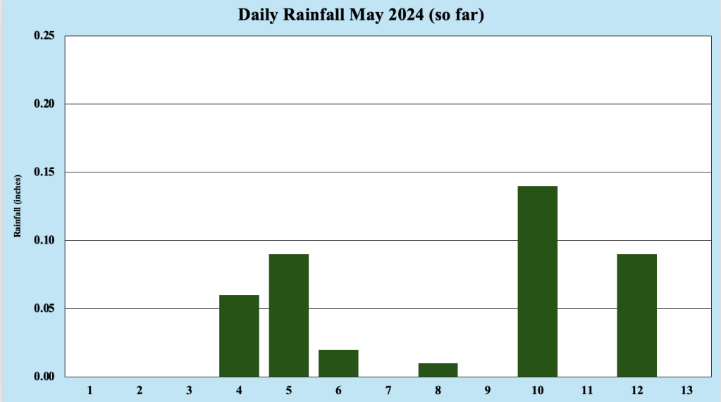
As mentioned earlier, rain has been measured on six of the first 13 days of May 2024, which is greater than usual frequency for rainfall. However, rainfall amounts have been relatively paltry, with less than one-half inch of rainfall collected in the Bellcrest section of Toms River, NJ (the normal amount of rain thus far is May is about 1.59 inches). Fast moving systems with little moisture with which to work have crossed the region about every other day, producing generally light rainfall amounts, which unfortunately appear to centered on weekends. Temperatures during the rainfall have tended to average below normal, making May 2024 feel more like an early spring month, rather than a month that ramps up toward summer.
The relatively fast flow across the US should limit rainfall amounts through at least the next week, but we may have to contend with a couple of light rainfall events, which could be accompanied by cooler than average temperatures. Unfortunately for residents and visitors to the Jersey Shore, bouts of rain and cooler temperatures are possibly all the way through Memorial Day, often hailed as the unofficial start of summer. Proximity to the still cool Atlantic Ocean allows an onshore flow to occasionally deliver cool and wet weather through much of May.
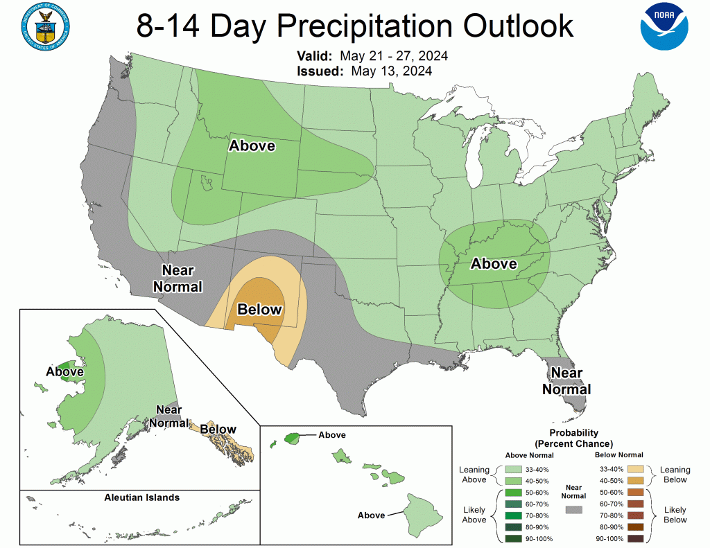
Since the pattern across the country is expected to remain fast for much of the remainder of May 2024, periodic mainly light rainfall events can be expected moving forward. NOAA’s CPC indicates more rainfall than usual for the period May 21 – 27 2024. Because of the swiftness of the pattern across the country, much of the rain is expected to remain light, with the threat of heavy rain appearing to be small at this point.

Leave a comment