Overview
Unlike the past few months, April 2024 was much closer to what might be expected during the first full month of spring in the Bellcrest section of Toms River, NJ. Other than a week of above normal temperatures in the middle of the month, normal variations in temperatures were experienced, and low temperatures did not drop below the freezing mark. Record rainfall during the first couple of the days of the month was followed by sporadic rainfall amounts of 0.25 inches or less for the remainder of the month, as the total rainfall measured just above normal for April. Of course, temperatures were much too warm for snowfall in April 2024 (though April snowfall has occurred in Toms River during the past), but we recorded our first three thunderstorm days of 2024!
Rainfall
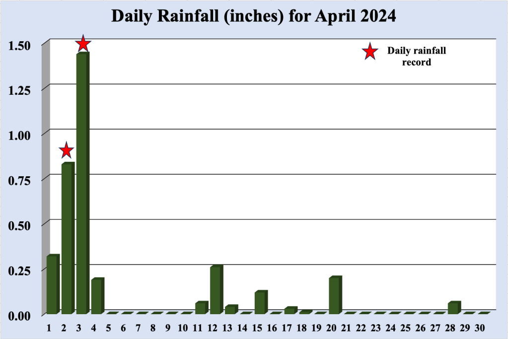
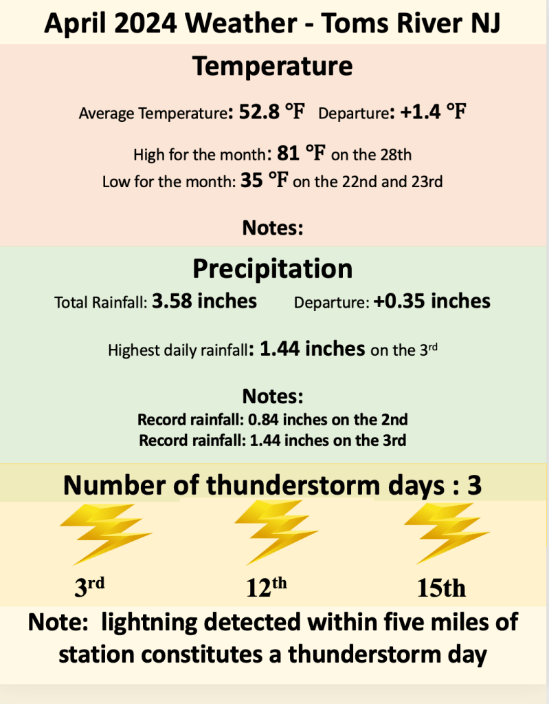
Nearly three quarters (72%) of all of the rainfall recorded during April 2024 occurred in the first four days of the month, with two new daily rainfall records established. After appearing as though the pattern would support yet another month of heavy rainfall, warmer temperatures pushed fronts north of the Jersey Shore, keeping much of the rainfall to the north as well. April is a transition month with respect to rainfall, as the extratropical lows (winter like storm systems) move north of the region with the the jet stream, but rainfall associated with thunderstorms generally do not arrive until later in the month.
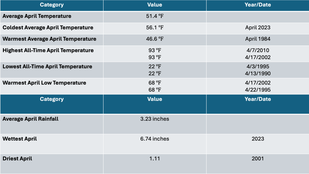
For the last three weeks of April 2024, rainfall was generally light, measuring less than 0.25 inches during each event. For the month, 3.85 inches of rainfall was recorded in the Bellcrest section of Toms River, which is close to the long term average of 3.23 inches. By comparison, the wettest April for this location occurred just last year, when 6.74 inches fell, and the driest April happened in 2001, when a mere 1.11 inches of rain was collected.
Temperature
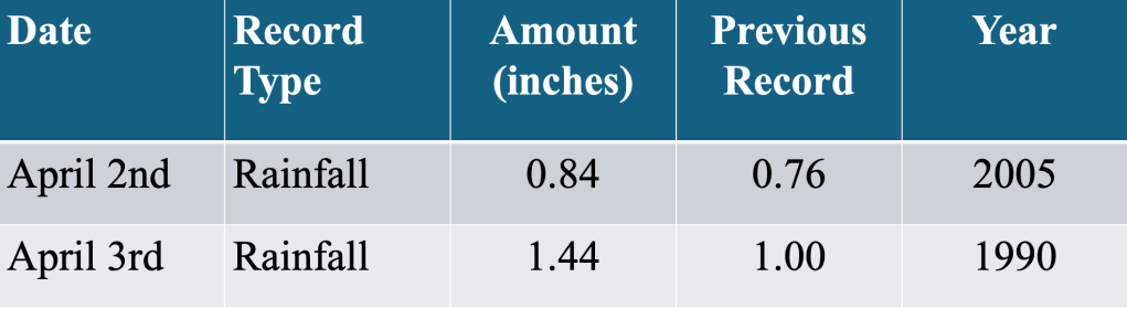
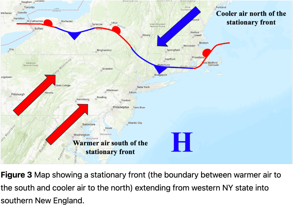
Unlike the past few months (when temperatures were well above normal with periods of near record high temperatures), April 2024 was slightly above normal. The month started with a week of below normal temperatures, as a frontal boundary remained nearly stationary across the Jersey Shore. However, as the jet stream moved north of the region, it took the front with it, bringing an extended period of above normal temperatures and dry conditions through mid month. Temperatures topped out near 80 degrees during this time, but no daily record high temperatures were threatened, as record high temperatures during mid April are generally between 85 and 90 degrees.
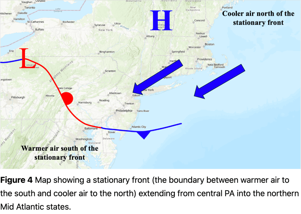
The frontal boundary again settled near the Jersey Shore for much of the remainder of April, with temperatures alternating between above normal and below normal. When temperatures popped during this period, surface winds shifted to the southwest, allowing warmer air to reach the shore. Winds shifted to the east and southeast when temperatures dropped along the shore, as ocean water temperatures are still in the cool mid to upper 40s.
Finally, though April 2024 was “only” about one and one-half degrees above normal, it marked the seventh month with above normal temperatures of the last eight months in Toms River. Only November 2023 experienced below normal temperatures during that streak.
Thunderstorms
Following a long drought, we finally logged some thunderstorm days in the Bellcrest section of Toms River NJ during April 2024! Our Tempest weather station can detect lightning from thunderstorms, measuring the distance from the storm to the station. Though the system can detect lightning up to 25 miles from the sensor, thunderstorm days are counted only if the lightning is determined to be within five miles of the station (just like at airports across the country).
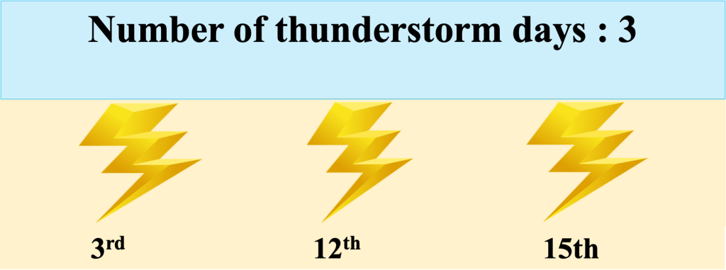
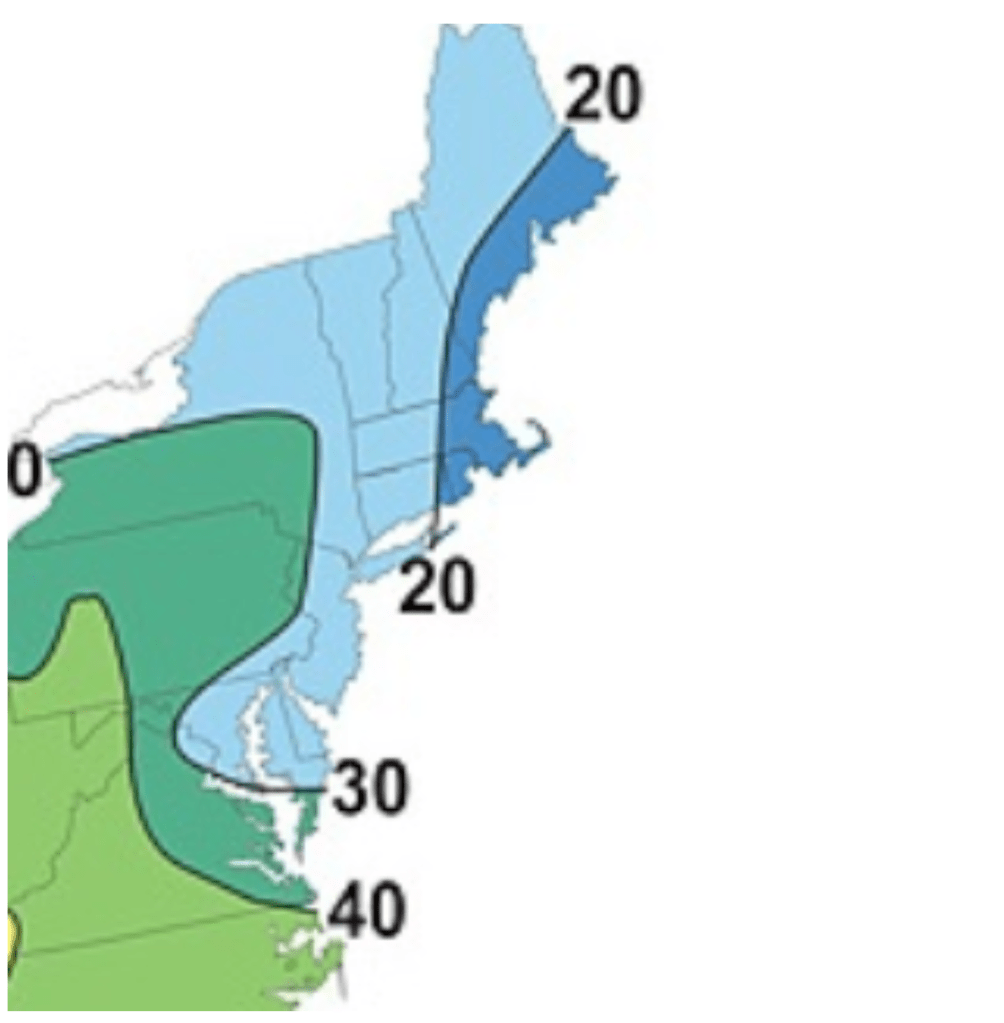
A total of three thunderstorm days were logged in Toms River, NJ, but that does not necessarily mean that only storm occurred during that calendar day. We are more interested in counting the number of days when a thunderstorm happened, rather than how many storms actually occurred. Figure 6 shows a map of the average number of thunderstorm days per year for much of the Northeast and Mid Atlantic states. Produced by Rutgers University, this map indicates that somewhere between 20 and 30 thunderstorm days can be expected along the Jersey Shore, and we tabulated 30 thunderstorm days using data from the Tempest weather station during 2023.
Coincidentally, we logged three thunderstorm days during April 2023 as well. Thunderstorms become more likely during April (especially the last half of the month) as the jet stream sets up north of NJ, pushing fronts across the region. Ahead of the fronts, warmer air (containing more moisture) streams northward, and the combination of warm air, moisture and lift associated with the front increases the possibility of thunderstorm development.
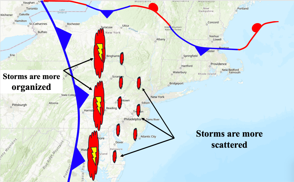
Not surprisingly, thunderstorms are more likely across eastern PA and western NJ (as seen in Figure 6), as these areas are not affected by an onshore flow that often covers the Jersey Shore. Thunderstorms that develop across eastern PA and western NJ tend to weaken as they approach the shore, encountering the cooler air near the coast. During April 2024, storms survived the trip across NJ and affected Toms River on April 3rd, April 12th and April 15th. Since there is no definitive source that tells us how many storms affect the Jersey Shore each month, we are excited to use the Tempest weather station to forge our own thunderstorm climatology for the Jersey Shore!

Leave a comment