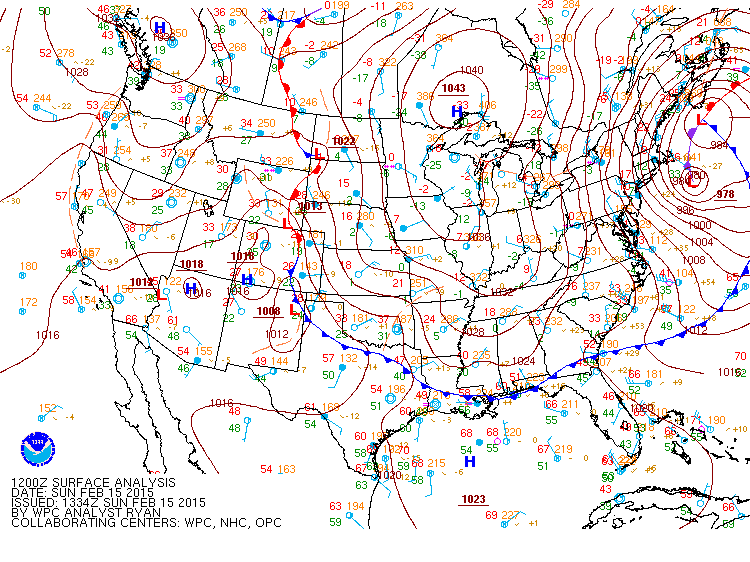
Figure 1 Weather Prediction Center’s (WPC) surface analysis on February 15th, 2015 at 7 pm. Note the strong high pressure system over southern Ontario. This system would deliver the coldest air of the coldest February on record to the Bellcrest section of Toms River, NJ.
Overview
During the first half of February 2015, temperatures in the Bellcrest section of Toms River were seasonably cold and conditions were mostly dry (outside of nearly an inch of rain on the 2nd). For the most part, weather conditions were unremarkable. Arctic air had been bottled up across northern and central Canada by a jet stream that stretched from west to east across the US. As a result, though temperatures were cold at night, there were no record breaking temperatures prior to February 13th.
Creating the coldest February on Record in Toms River, NJ
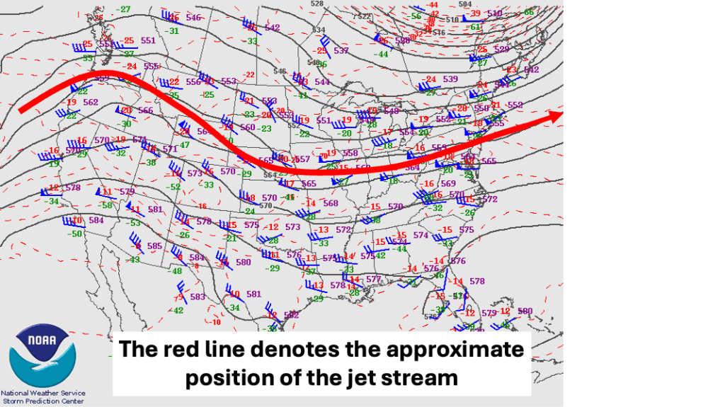
By February 13th, 2015, changes in the position and magnitude of the jet stream indicated that colder air, held at bay across northern Canada for much of the month, would be allowed to surge southward into the US. An Arctic cold front crossing the Northeast brought with it the first taste of cold weather, resulting in a record low temperature (8 F) being established in the Bellcrest section of Toms River, NJ.
However, a buckling jet stream across central and eastern Canada would deliver the coldest air in years to portions of the Northeast. Figure 3 shows the approximate position of the jet stream. Note that the flow comes down from northern Canada. This flow configuration is often referred to as “cross polar flow” because, as the name implies, the air is drawn from the North Pole directly southward. Air flowing directly over the North Pole has little time to modify, and is often the source of the coldest air in NJ.
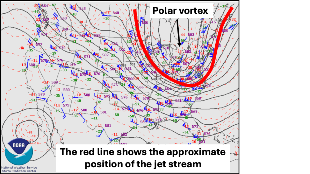
Also note the Polar Vortex over southern Ontario. This feature is typically associated with the bulk of the Arctic air in the Northern Hemisphere. The polar vortex is always present; in the summer it is weak and resides near the pole. In the winter it flops from one side of the pole to the other, generally in the vicinity of the coldest air. This example of the polar vortex is much like the one the media latches onto at least once a winter, and is a fair representation of what the polar vortex looks like during most winters.
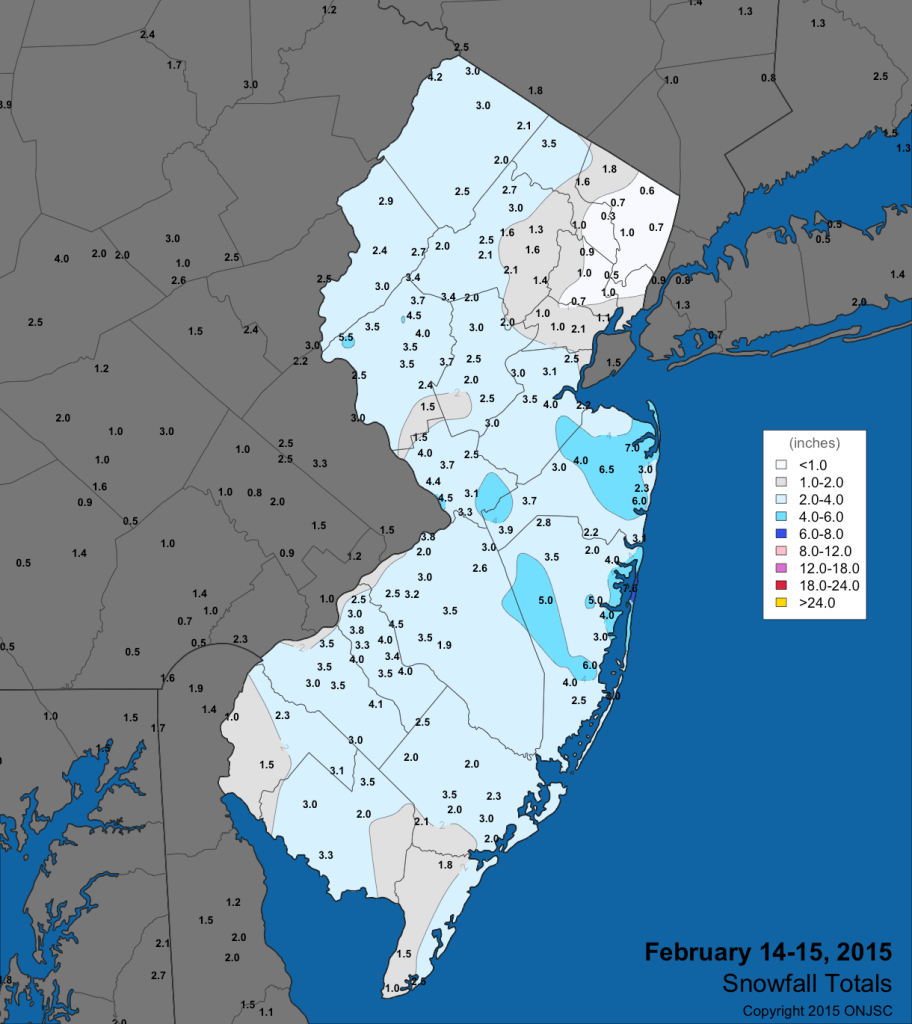
As the Arctic cold front crossed the Mid Atlantic and Northeast states during the overnight hours of February 14th/15th 2015, a surface low pressure system developed on the front, in response to the polar vortex. While the moisture content of the air was limited, the upward motion near the front and surface low made the most of it, producing accumulating snow across much of the state, with amounts exceeding 5 inches across central NJ. That surface low deepened as it moved off the coast and produce heavy snow in portions of New England during the 15th of February.
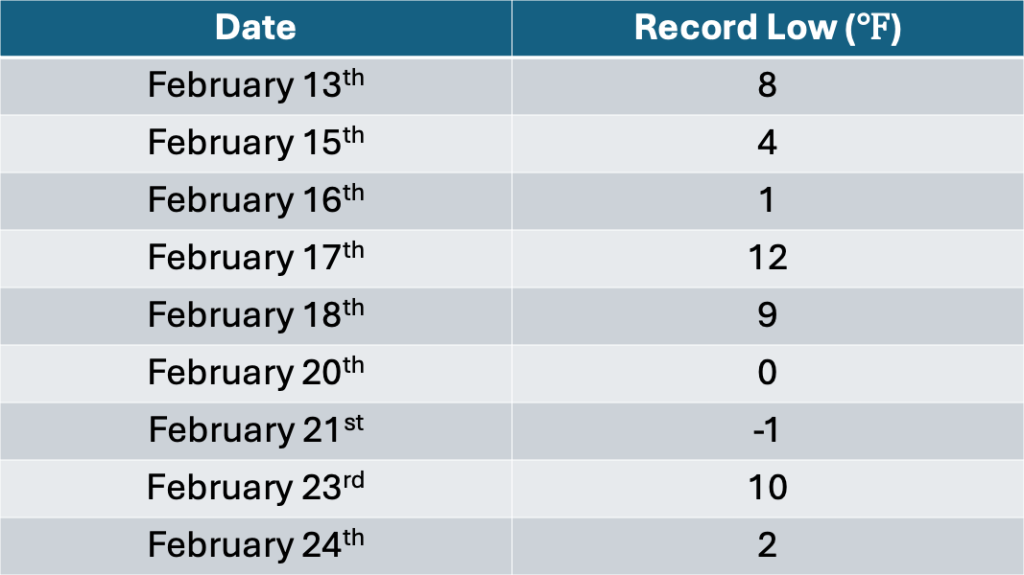
Perhaps more important than the snow was the intrusion of the Arctic air across NJ. Once the jet stream pattern was established, the Arctic remained locked in across NJ for the next 10 to 14 days. During that time, eight new daily record low temperatures were recorded in the Bellcrest section of Toms River, NJ (where temperature records date back to 1978) in the space of 10 days. Impulses located within the polar vortex created enough lift for small snowfalls across central NJ during that time, building a snow cover that would remain in place through almost the rest of the month.
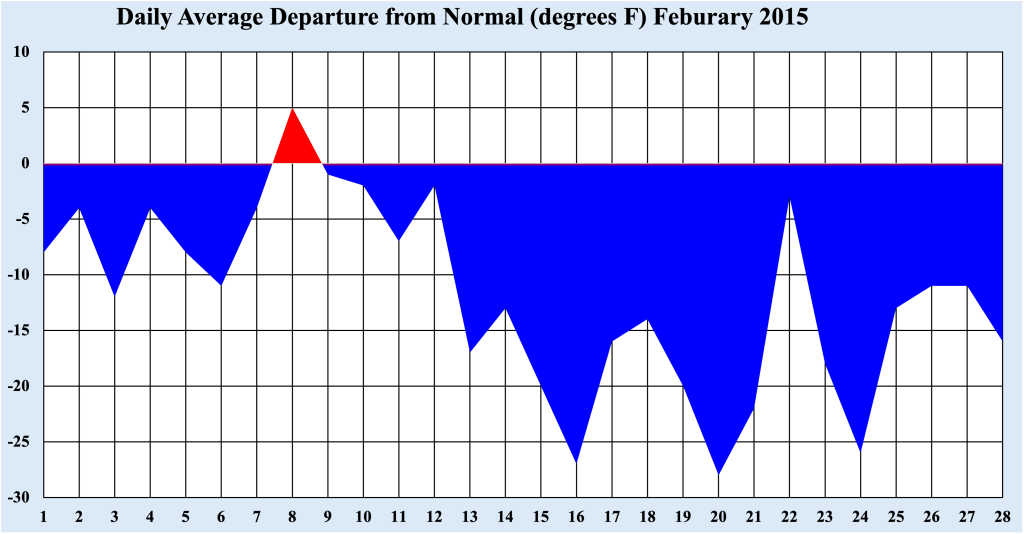
Though the core of the Arctic air began to ease after February 24th, cold air remained in place across the Jersey Shore. In fact, only one day during the month (February 8th) had an average temperature above normal. Every other day of the month had an average temperature below normal, with temperatures reached 25 to 30 degrees below normal within the heart of the Arctic air between February 16th and February 24th. The pervasiveness of the cold, particularly after St Valentine’s Day, rivaled the coldest period in the history of the Bellcrest section of Toms River, which occurred during December 1989.
The Legacy of the cold of February 2015
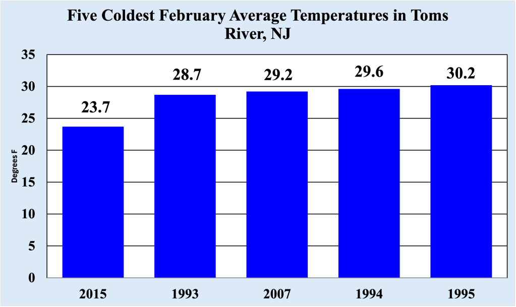
February 2015 was the coldest February on record for the Bellcrest section of Toms River NJ (where temperatures records date back to 1978). In fact, it was a full five degrees colder than the second coldest February (1993), which is impressive considering this is the coldest time of the year. February 2015 is also the second coldest calendar month for the location, just a few tenths of a degree warmer than December 1989.
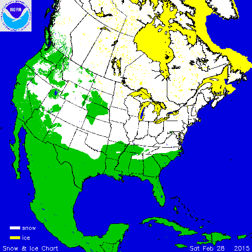
Consistent cold covered much of the northern portion of the US as well, resulting in the most extensive snow cover in February across the US in many years. Snow cover often keeps new airmasses from warming they would receive by passing over bare ground (which is one of the key reasons cold spells along the NJ coast do not typically last more than a few days). Arctic air passing over a snow cover keeps the air as cold as possible, which explains the cold experienced during the last two weeks of February 2015.

Leave a comment