After the snow and cold of late this week and the weekend, winter eases a bit in the eastern United States, with warmer than normal temperatures returning by the middle of next week. A change in the overall weather pattern is responsible for the change, as warmer air shifts from the Rocky Mountain of the United States to practically overhead of the Jersey Shore.
To understand why this change is occuring, we need to discuss how the atmosphere works (at least in a simplified manner), and how the cold air overhead this weekend can be replaced with the warmer air to come. Though the weather we experience seems to occur at the surface (heat, cold, rain, thunderstorms), weather actually develops in the mid levels of the atmosphere, which then transfers the energy to the surface (causing the weather we experience).
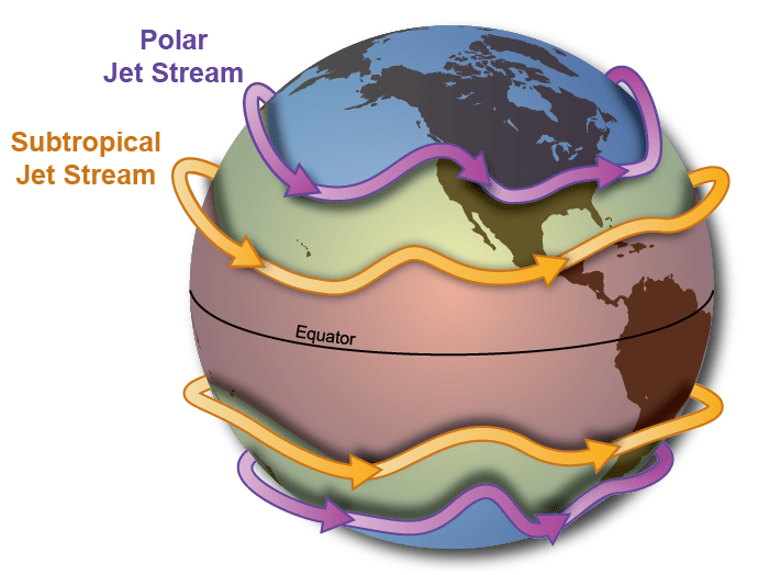
Figure 2 shows the position of the jet streams in the atmosphere. The jet stream is a fast, narrow current of air flowing from west to east that encircles the planet. The jet stream acts as a sharp boundary between contrasting air masses, with relatively warm, tropical air to the south and much colder air on the northern, poleward side. The location of the jet, and hence also the boundary, has a strong influence on temperatures down at the surface.
In addition, the jet acts to steer weather systems, and is the primary driver in the development and movement of weather that affects the surface. Finally, there are kinks in the flow of the jet stream, which happen where there are large differences in temperature. These kinks are known as ridges and troughs.
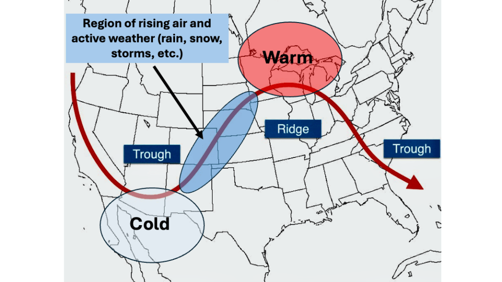
Figure 3 shows a conceptual model of the mid levels of the atmosphere (at about 18,000 feet). In this image, the maroon line represents the jet stream. Within in the jet stream, a ridge of high pressure (think of a ridge as a mountaintop) extends from the Great Lakes south to the Gulf Coast . Air near a ridge (and to its east) falls through the atmosphere (as if it was riding a roller coaster car from the top of the mountain downward). When air falls in the atmosphere, it warms (through a process known as adiabatic compression, a concept which is beyond the scope of this blog entry). As the air descends, it also dries out, meaning that there are generally less in the way of clouds associated with mid level ridges.
In Figure 3, a trough of low pressure (think of a trough as a valley) extends from Idaho south into Arizona. Air near a trough (and to its east) rises through the atmosphere (as if it was riding a roller coaster car up the track toward the top of the mountain). When air rises in the atmosphere, it cools. As the air cools, it becomes more moist, meaning there are generally more clouds associated with a mid level trough.
Troughs and ridges move along with the jet stream, and others develop in response to changing temperatures near the jet stream. The moving troughs and ridges can influence each other. For example, a strong trough (like the one depicted in Figure 3 over the Southwest US) can push up against the ridge and cause it to weaken with time. Timing the changes in strength and position of the troughs and ridges in the mid levels of the atmosphere is the primary forecasting challenge to meteorologists.
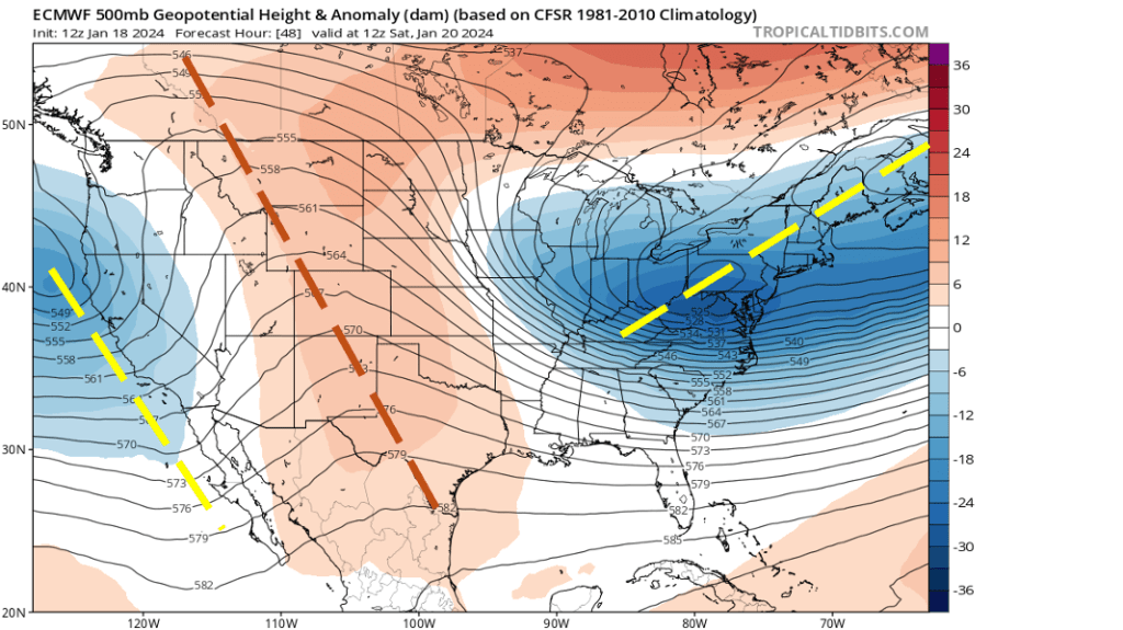
So, how will the positions of the troughs and ridges in the mid levels of the atmosphere affect our temperatures from Saturday into the middle of next week? Figure 4 shows the European Centre for Medium Range Weather Forecasting (ECMWF) model forecast of the mid level flow over the US on Saturday, January 20th, 2024. Note the very strong trough (depicted by the yellow dashed line) extending from Maine into Kentucky. This trough is responsible for the cold and snow during the past 10 days.
Also note the ridge extending down the spine of the Rocky Mountains from Montana into west Texas. Air associated with this feature in descending, meaning that is is drying and warming. Finally, there is another trough along the coast of California. It is this trough that will result in the change in the weather pattern for the Jersey Shore.
As the trough along the California coast moves east, it will push the ridge over the Rockies to the east, which in turn pushes the trough over the East Coast this weekend out to sea. During this transition, temperatures will begin to warm over New Jersey, as the air associated with the mid level ridge approaches.
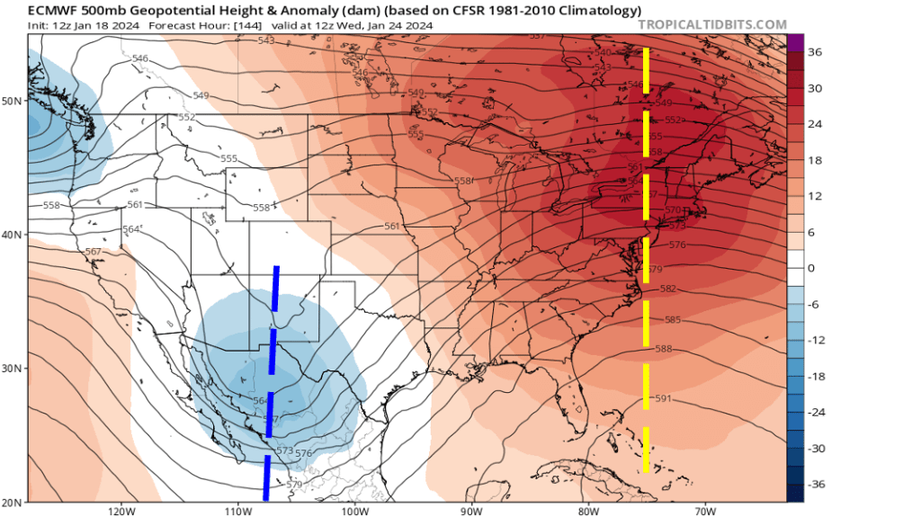
Figure 5 shows the ECMWF model forecast of the mid level flow over the US on Wednesday, January 24th, 2024. By this time, the ridge has taken its place over the East Coast, as the mid level trough has parked itself over the Southwest US. Descending air associated with the ridge will allow temperatures to rise above normal over the Jersey Shore, with highs in the 40s.
If you look closely as Figure 5, you will see that the ECMWF model shows yet another trough approaching the Pacific Northwest. Though it is beyond this range of this forecast, that trough in the Pacific Northwest will eventually replace the trough over the Southwest US, keeping the mid level ridge (and warmer temperatures) over the Northeast US through the end of January.
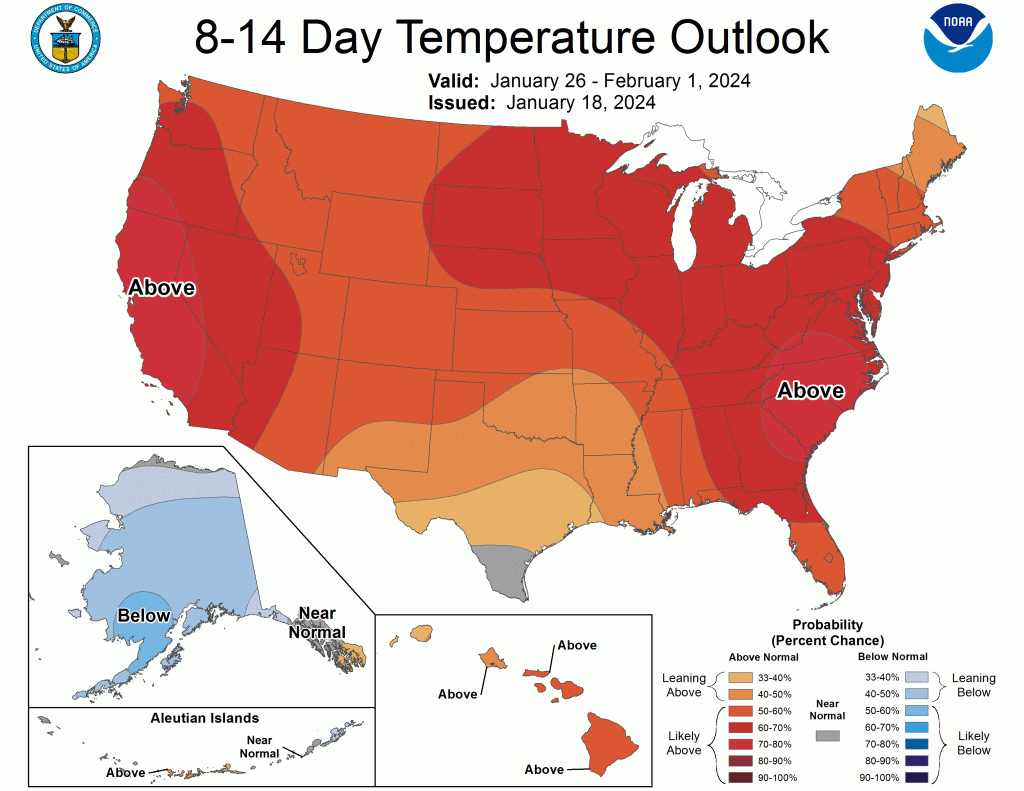
Looking back at Figure 1, NOAA’s Climate Prediction Center (housed in College Park, Maryland) is indicating above normal temperatures for much of the US through February 1st, 2024. If you are a snow lover, enjoy the snow while you can, because after this weekend, the next snow for the Jersey Shore may not occur before early February, at the earliest.

Leave a comment