Some background on winter storms that affect the Jersey Shore
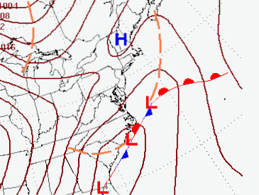
While there is still quite a bit of uncertainty surrounding the forecast for Tuesday, January 16th, there is a possibility that the Jersey Shore will see its first accumulating snow of the 2023/2024 winter season. Most of the uncertainty lies in the track that the developing low pressure takes, and how close the precipitation associated with the low gets to the Jersey Shore. (For simplicity’s sake, the terms low pressure system and storm are used interchangeably in this post, as they are the same thing in this context).
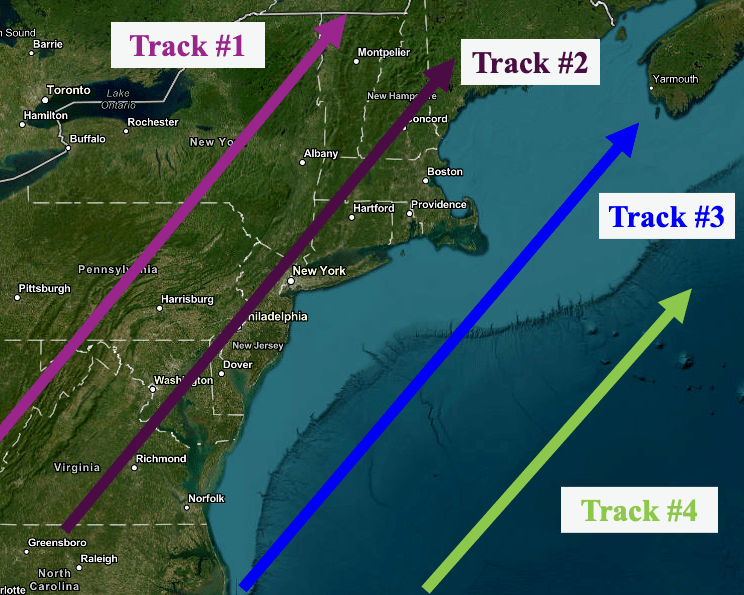
Figure 2 shows the typical tracks winter storms take with respect to the Jersey Shore. So far this winter, storms have had paths depicted by Tracks 1 and 2. These tracks allow warmer air to invade the Jersey Shore from the ocean, resulting in a mainly rain event for places like Toms River, NJ. If the air ahead of the storm is cold enough, occasionally the precipitation starts as snow, but that has not yet happened on the Jersey Shore early this winter. Unfortunately for snow lovers, these tracks can be the dominant path for storms, meaning that the NJ shore receives little snow during the winter.
For the the low pressure system expected to develop along the Mid Atlantic coast Tuesday, colder air in place suggests that it will take either Track 3 or Track 4 as it moves from NC to east of the New England coast. Track 3 is sometimes referred to as the Dream Track, as this path for storms often brings the heaviest snowfall the the Jersey Shore, and this is the track that the biggest snowstorms in Toms River during the past 30 years have taken. However, there is a major caveat with Track 3. If there is insufficient cold air in place before the storm arrives, snow can change to rain along the immediate coast, as milder air from the ocean warms the air just enough to cut down on snow amounts.
Track 4 is generally too far offshore to allow the precipitation associated with the storm to affect the Jersey Shore with heavy snow. Light snow can produce a couple of inches of snow, but the biggest snow with Track 4 is often across New England. This track also causes the biggest headaches for forecasters, as determining just how far offshore the storm will move can be the most difficult forecasts to make during the winter season.
The Winter Forecast Problem
As is often the case, there is a large variation in solutions with respect to the track of the surface low expected to affect the East Coast early next week. Two of the most reliable forecast models, the Global Forecast System (GFS, an American run model) and the European Center for Medium Range Forecasting (ECMWF, a privately owned and run model originating in Reading UK), are showing drastically different solutions valid at the same time Tuesday. Unfortunately, this is a conundrum that forecasters often face during the winter. Most times, as we draw closer to the event, the models come into better agreement, increasing forecaster confidence concerning the impacts to the East Coast (though that is not always the case).
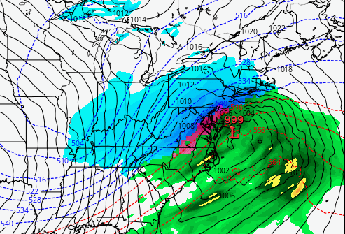
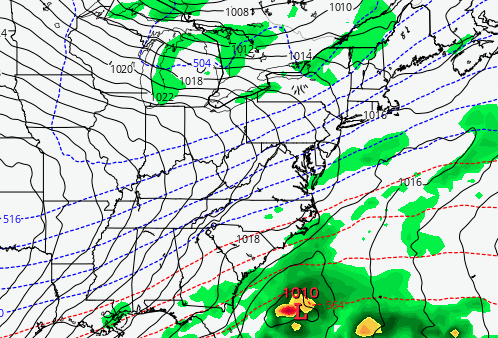
The GFS shows a storm that takes Track 3, which would favor heavy snowfall for the Jersey Shore. In this case, the model is suggesting that just enough mild air in drawn in from the ocean to cause a change from snow to rain, meaning that Toms River could see accumulating snow before a change to rain takes place. The ECMWF model shows a surface low off the Southeast US coast, which would take a path close to track 4. The ECMWF solution (valid at the exact same time as the GFS) would suggest that the precipitation with the low will remain largely offshore, and that the Jersey Shore might get some light snow. Obviously, the difference in impacts to NJ are huge.
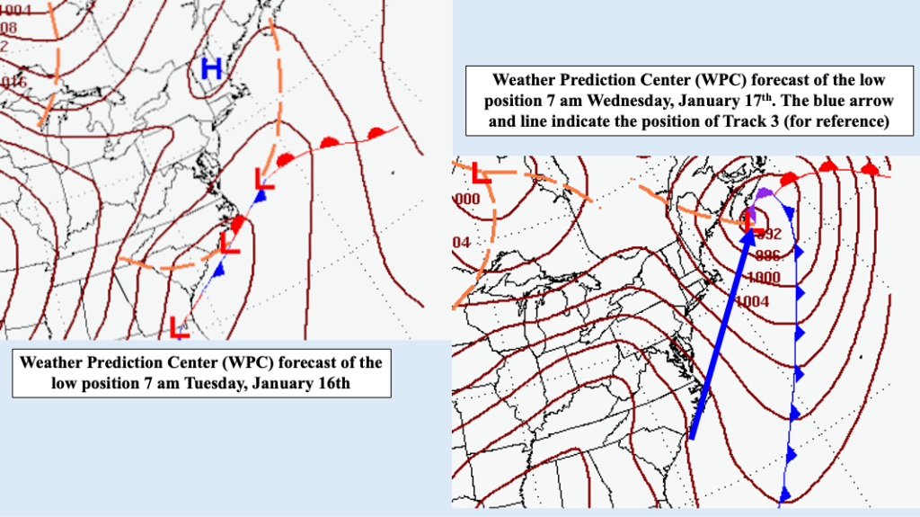
Within the National Weather Service is the Weather Prediction Center (WPC), where a group of forecasters use the latest model runs, as well as other data sources and forecast techniques (most of which lie outside of the scope of this blog entry) to eliminate some of the uncertainty in the track of low pressure systems. Their solution most closely resembles Track 3, but the WPC forecast of precipitation with the expected storm is lower than might be anticipated given the path of the storm. The utility of WPC is to mitigate differences in model solutions to arrive at the most likely scenario, not to be exact. As the timing and placement of the surface low becomes clearer, WPC will refine their forecasts.
The Verdict
Not surprisingly, it is MUCH TOO EARLY for specifics for the possible storm affecting the Jersey Shore early next week. The potential is there for accumulating snowfall along the coast, but at this point there are still too many question marks when it comes to specifics. The intent of this blog entry was to demonstrate some of the difficulties facing forecasters when attempting to gauge the impact a winter storm might have on the East Coast, as well as offer some insight into how forecast decisions are made.
Bottom line: STAY TUNED to your local weather forecasts for the potential for snow early next week,

Leave a comment