Overview
The Bellcrest section of Toms River, NJ is located on the central NJ shore in eastern Ocean county. Its proximity to the ocean typically modifies the influence of cold during December, and can be the major reason for rain falling here while snow falls in other portions of NJ. Normal high temperatures in the lower 40s F and low temperatures in the mid 20s F, while not the coldest part of winter in Toms River, qualify as winter day. These values would indicate Christmas Day dawns with temperatures well below the freezing mark and highs about 10 degrees above freezing.
For the Bellcrest section of Toms River, temperature data for Christmas Day extends back to 1980, contains a break between 1986-1988, and a couple of years during the mid 1990s. Rainfall data is available starting in 1989, with the data missing during the same time temperature data is missing in the mid 1990s. These restrictions yield temperature data for 39 Christmas Days, and rainfall data for 32 Christmas Days. Unfortunately, due to the lack of a consistent observer at this location, snowfall was not observed on a regular basis, and is not included explicitly in this review. Snowfall from nearby locations is employed in an attempt to gauge the likelihood of a white Christmas along the central NJ shore.
Temperature
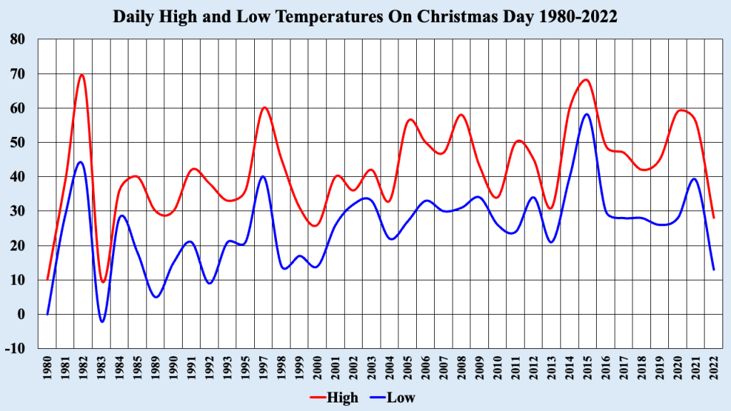
Figure 1 shows a plot of the observed high and low temperatures in the Bellcrest section of Toms River, NJ between 1980-2022 (with some data missing). While the normal high is in the lower 40s and the normal low is in the mid 20s, these temperature traces show larger than expected deviations from the mean. Following the two coldest Christmas Days on record in this location (1980 and 1983, sandwiching one of the warmest Christmases ever), there is a general increase in both high and low temperatures for the date, even accounting for the occasional colder than normal holiday). Large spreads in temperature for Christmas Day echo what has been discovered at this location in Toms River, NJ for the remainder of the dataset.
Rainfall
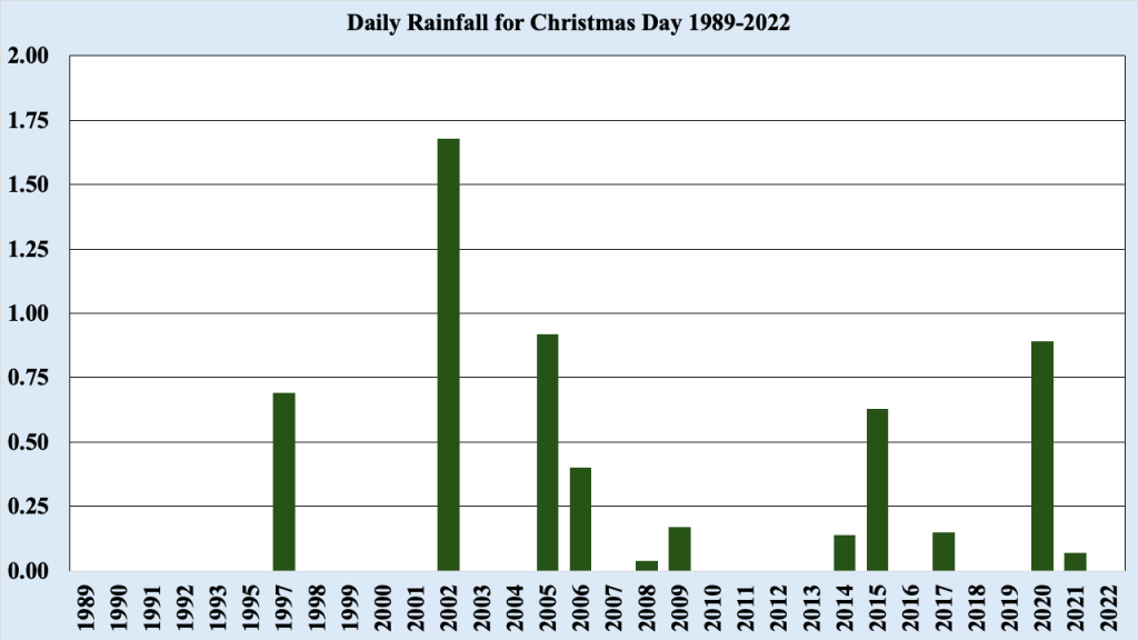
Between 1989 and 2022, rainfall was observed 11 times during the 32 year span, averaging measurable rainfall every three Christmas Days. This matches the overall rainfall pattern for this location, with rainfall measured about every third day throughout the year. By far the largest amount of rainfall recorded on Christmas day occurred in 2002, when a deepening low pressure system over southern NJ resulted in heavy rain changing to heavy snow before ending during the evening hours.
Snow on the Ground Christmas Morning
Traditionally, a white Christmas has been defined as having one inch of snow on the ground at 7 am on Christmas morning. Generally, a measured inch of snow provides enough snow cover to allow observers to refer to it as a white Christmas (though there is not technical definition of a white Christmas). The time was chosen since it is the time most observers report their snow cover for the day (the same is true at most airports in the US as well). That time occurs at 12 Universal Coordinated Time (UTC), meaning that all observers across the world are supposed to report snow cover at that time to provide an estimate of snow over across the globe (at least before the advent of satellite estimated snow cover).
As mentioned earlier, since there was not always an observer available to measure snow in our location in Toms River, we chose not to include that element as part of our weather database. However, there are a couple of locations close by from which we can infer how much snow MIGHT have fallen at our location. Cooperative observers (members of the public that reports weather information each morning at about 7 am to their local National Weather Service (NWS) office or to a central collective via the Internet) report snow cover around Toms River. The closest is in Toms River, near the Garden State Parkway, about four and one-half miles from the Bellcrest site, and snow cover is reported at 7 am. There are gaps in the data, as might be expected, but there is enough data to draw some conclusions about the estimated snow cover at our location.
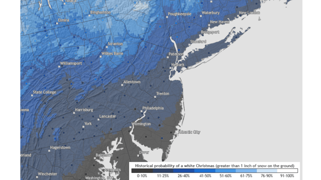
NOAA/NWS created maps of the probability of a white Christmas at our location in Toms River show there is a less than five percent of occurrence, which is not a surprise to anyone living in the vicinity. In fact, a review of the snow cover information for the cooperative observer in Toms River did not show ANY white Christmases as we define them, during the period 1980-2022. While I seem to remember at least one white Christmas sometime in the late 1960s, my memory seems to confirm what NOAA/NWS and the cooperative observer indicate; a white Christmas is an exceedingly low probability event on the central NJ shore.
While the NOAA/NWS probability map was derived from information spanning 1990-2010, it seems to provide a fair estimate for a white Christmas. When I lived in southern ME (just northeast of Portland), we had a white Christmas 7 of the 13 Christmas Days I was there, which is close to what the NOAA/NWS probabilities indicate. Of course, timing is also important. On Christmas Day 2002, we had no snow on the ground at 7 am, but by that evening, more than a foot of snow had accumulated. So while we did not technically have a white Christmas, it was certainly white shortly afterward.
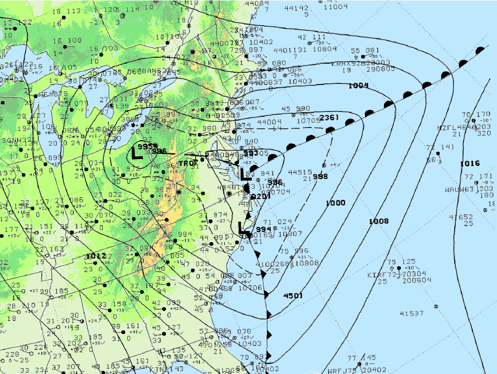
There was a close call regarding a white Christmas in Toms River in 2002. Figure 4 shows low pressure weakening over eastern OH before a secondary low formed over southern NJ during the early afternoon. Heavy rain developed in the relatively mild easterly flow ahead of the low, but as it deepened on its way to New England, colder air on the back side of the system changed the rain to snow in Toms River. My brother measured about an inch and one-half of snow late in the day, but it could have been higher due to melting and compression. Had the snow occurred 12 hours earlier, Christmas Day 2002 would have qualified as white Christmas.
Another close call occurred in 2010. Snow did not fall on Christmas Day, and there was no snow on the ground at 7 am on that day. However, strong low pressure affecting the mid Atlantic and Northeast produced a swath of two feet of snow (or more) from near DC to south of Boston on December 26th 2010. That snowfall remained in place for more than a week, and the storm that produced has been referred to as the Boxing Day Snowstorm of 2010.
A cold Christmas: December 25th, 1983
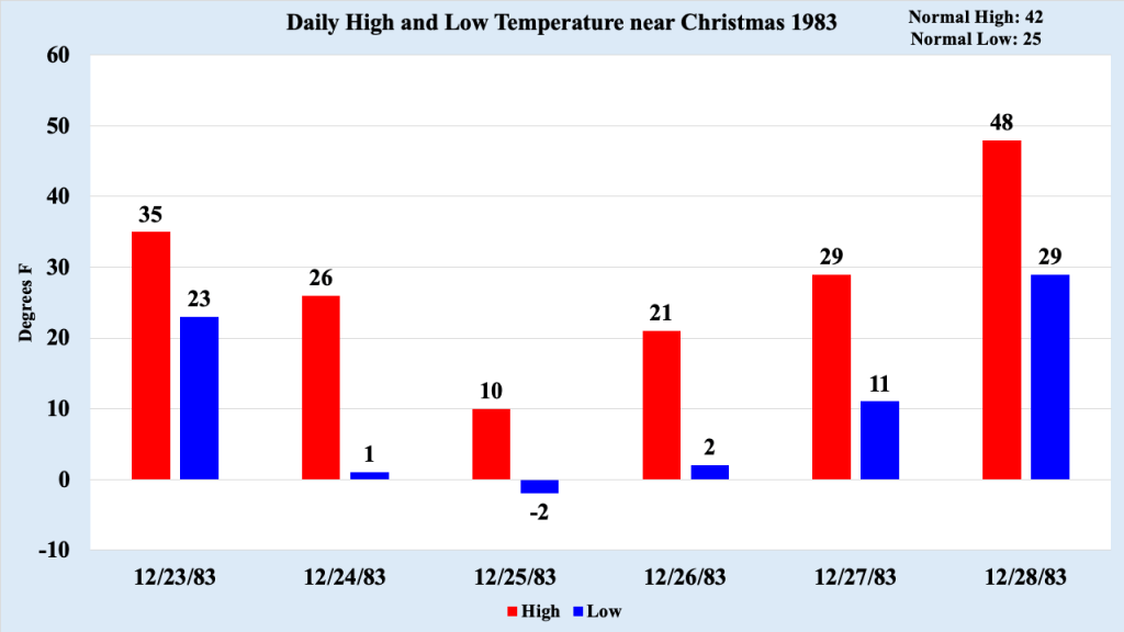
The two coldest Christmas Days in our database occurred in the early 1980s, near the very beginning of our recording keeping days. Christmas Day 1983 was the coldest, with a high temperature of 10 degrees F and a low of -2 degrees F (marking the only time a temperature below zero was recorded on Christmas Day in our database). An arctic front passed through the region during Christmas Eve. A few snow showers accompanied the front, but not enough to cover the ground. Gusty northwest winds blew away any snow that did accumulate, as temperatures slowly dropped in the afternoon into the evening, setting the stage for the coldest Christmas day. Though Christmas Day itself was sunny, the high of 10 degrees F is tied for the second coldest high temperature in our dataset.
The blast of cold air was relatively short lived. The core of the arctic air remained in place through December 26th, then slowed moderated, with temperatures rebounding above normal by the 28th. The second coldest Christmas in the Bellcrest section of Toms River happened in 1980. On that day, the high temperature was also 10 degrees F, and the low temperature bottomed out at zero degrees F. Much like the arctic blast in 1983, the coldest air occurred on Christmas Day in 1980, with temperatures bouncing back above normal by the 28th.
A warm Christmas: December 25th, 2015
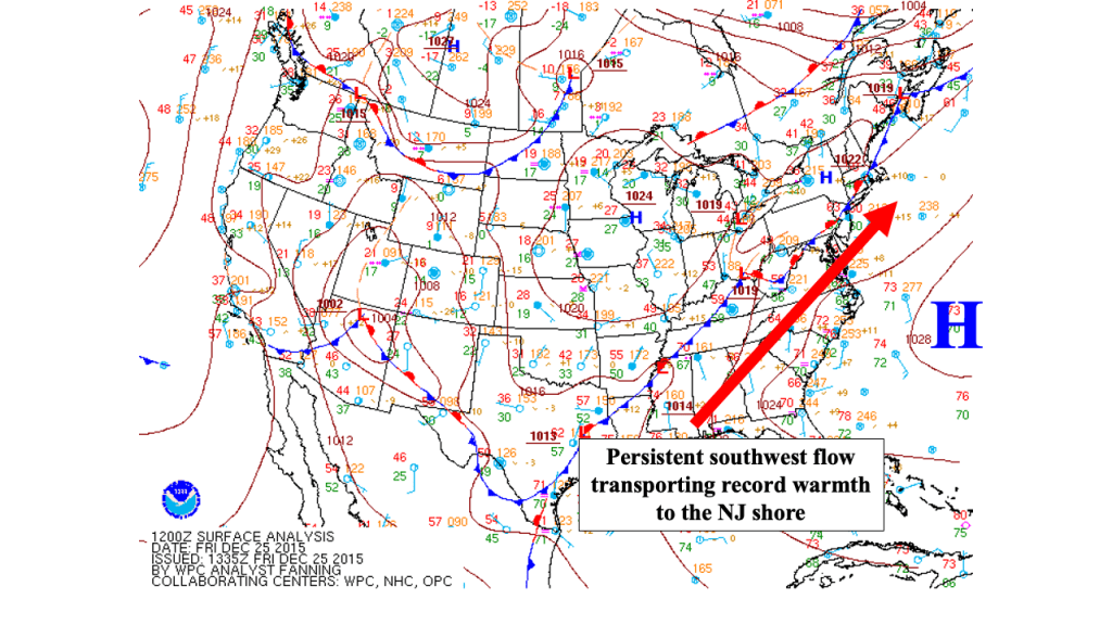
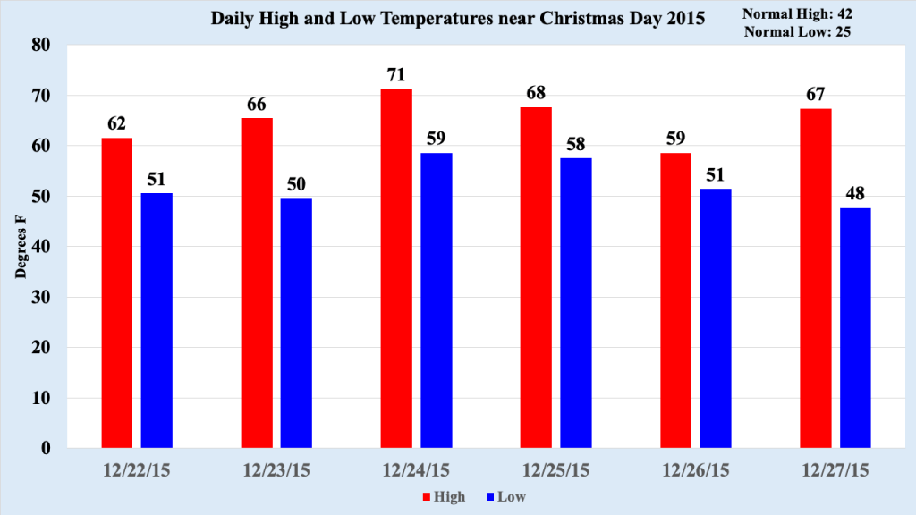
December 2015 was the warmest December on record in the Bellcrest section of Toms River, NJ, more than five and one-half degrees warmer than the next warmest December (1982). A persistent pattern (featuring a Bermuda High located off the NC coast, which is often responsible the hottest and most humid weather in the summer) pumped record warmth into the mid Atlantic and Northeast states for much of the month. Seven new record high temperatures for the date were established during the month, as well as 11 record high low temperatures, outlining how anomalously warm the pattern had become. The greatest stretch of warmth spanned from December 22nd through December 27th, including the warmest Christmas Day on record at this location.
High temperatures in the upper 60s and lower 70s were 25 to 30 degrees above normal for the date. Low temperatures were also between 25 and 35 degrees above normal (normal low temperatures on Christmas Day are in the mid 20s), and the airmass was actually felt humid, and I actually employed air conditioning during this time (I was living near DC in 2015). For the first time in my memory, people were wearing shorts in the days leading up to and just after Christmas. After the 27th, temperatures started cooling off toward normal, but that six day stretch remains the warmest period during a winter month in the Bellcrest section of Toms River, NJ.
Review
Christmas Day in the Bellcrest section of Toms River typically experiences highs in the 40s and lows in the 20s, with rainfall recorded every third Christmas Day. However, many Christmas Days featured very warm or very cold conditions, but none of them technically qualified as a white Christmas (one inch of snow on the ground at 7 am Christmas Day). Two sources indicate very strongly that white Christmases along the central NJ are exceedingly low (less than five percent). Will we have a white Christmas this year, despite the long odds? We will have to wait until about seven days before Christmas to learn if there is even a chance, and probably two or three days before to see if the chances are much above normal.

Leave a comment