Following a rare Thanksgiving Day snowstorm on the New Jersey shore in 1989, arctic air plunged into the region, beginning the coldest month on record for the Bellcrest section of Toms River, NJ (where temperature records extend back to 1978). For the next five weeks, wave after wave of bitter arctic air spilled into the area, setting record low temperatures from late November into much of December. Unfortunately for snow lovers, the airmass was so cold that the storm track was pushed south, allowing the Southeast United States to experience an historic snowfall on Christmas eve. By the end of December, the arctic air began its retreat, followed by above normal temperatures for January and February 1990.
Overview
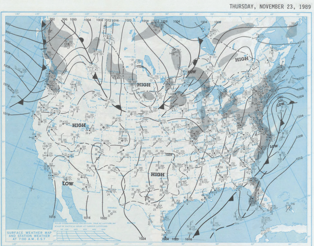
The weather pattern that would deliver the coldest December on record in Toms River NJ took shape during the second half of November 1989, after the passage of a strong cold front that brought severe weather to the NJ shore (and tornadoes across northeast PA). Behind the front, arctic air spread into the region, setting the stage for the earliest significant snowstorm I had ever seen. By the time the snow tapered off to flurries on Thanksgiving morning 1989, we measured six inches of snow in Toms River, and portions of New England saw upwards of a foot. Behind the low pressure system responsible for the snow, the first arctic blast was entering the northern Plains, headed for the Northeast.
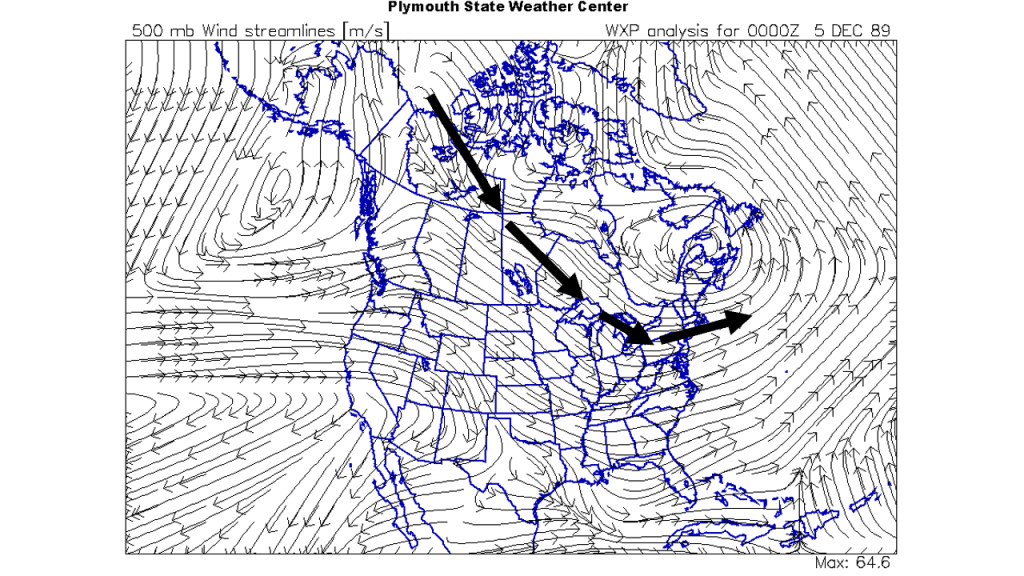
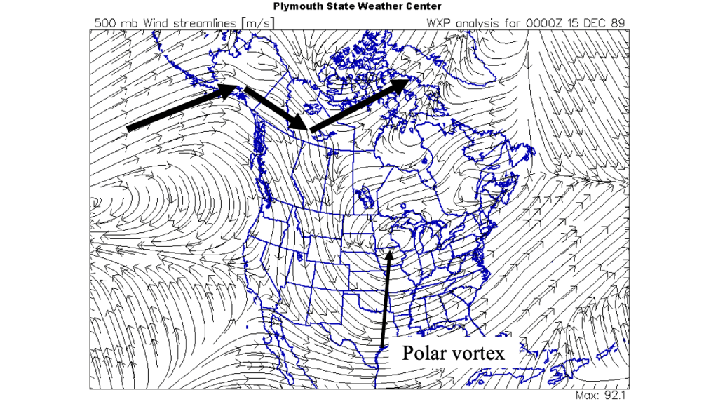
The overall weather pattern was shaping up for a cold December 1989, as the flow in the mid levels of the atmosphere showed a connection to the Arctic (Figure 3). Typically, when an arctic blast of air affects the NJ shore, it is followed by a period of milder weather, as the polar regions reloads with cold air. However, the mid level pattern indicated that the connection to the Arctic would remain strong, as the swirl over maritime Canada and southwest flow over Greenland would set up what is commonly referred to as a “blocking pattern”. In this setup, the position of these two mid level weather systems would ensure that the flow from the Arctic to the Northeast US would continue, delivering shot after shot of brutally cold air to NJ.
Creating the coldest December on Record
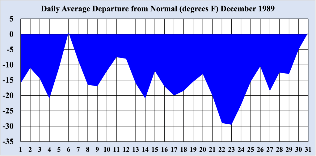
Record low temperatures were established for the first four days of the month, averaging between 15 to 20 degrees below normal for early December. In fact, on the 4th, the recorded high temperature of 26 degrees F was the coldest so early in the winter season. The first arctic blast was dry, so no snow accompanied the record cold weather. While it is technically never too cold for snow to fall, in practical terms, this airmass was so cold that it could not hold sufficient moisture to support more than a few flurries. In most cases, heavy snow tends to fall on the boundary between cold air and warm air, and during early December 1989, this boundary had been pushed well south of NJ.
| Date | Record Low (degrees F) |
| December 1st | 19 |
| December 2nd | 16 |
| December 3rd | 15 |
| December 4th | 12 |
| December 9th | 15 |
| December 14th | 8 |
| December 15th | 12 |
| December 16th | 13 |
| December 17th | 11 |
| December 18th | 10 |
| December 19th | 9 |
| December 21st | 7 |
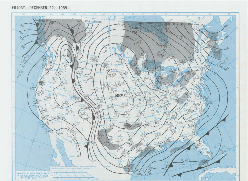
| December 22nd | 2 |
| December 23rd | 0 |
| December 27 | 5 |
In between arctic blasts, the aforementioned boundary moved back north, allowing moisture to return to central and southern NJ on December 8th. There remained sufficient cold air in place to produce between two and four inches of snow across the NJ shore. Unfortunately for snow lovers, this would be the biggest snowfall of the month, but colder air rushing back into the region behind the storm allowed the snow to remain in places for days afterward. That would prove important, as the snow on the ground did not allow the fresh arctic air to modify, as it would if there was no snow on the ground.
Coldest Air in the Coldest Month
Between December 14th and December 23rd 1989, new record low temperature were established on nine of the tens dates, with the low on the 23rd reaching zero degrees F. During that time, the mid level flow was transitioning, as the coldest air split off from the arctic connection. The heart of the coldest air during the coldest month for Toms River NJ was delivered via the polar vortex. The polar vortex is always present in the mid levels of the atmosphere. It generally resides near the North Pole during in the warmer months, dropping south into Canada during the colder months. Occasionally, the polar vortex becomes detached from the Arctic and drifts into the northern US, as it would during mid December 1989. As the mid level swirl tracked across the northern Plains into the Great Lakes, the flow brought the coldest air to the New Jersey shore, with the coldest day being December 23rd.
Breaking the Back of the Cold
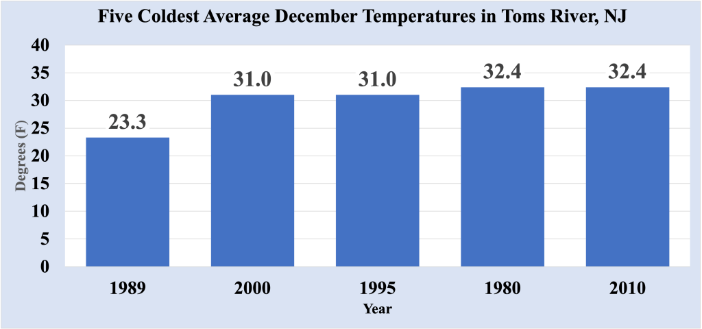
Though one more record low would be established on the morning of December 27th 1989, the core of the arctic air had moved across New England, bringing with it the end of the coldest December in the Bellcrest section of Toms River, NJ (at least since 1978). By New Year’s Eve, high temperatures had reached back into the 40s with rain to end the year. December 1989 had an average temperature of 23.3 degrees, an astounding 14.7 degrees below normal! Not surprisingly, December 1989 was almost eight degrees colder than the second coldest December, and the single coldest month ever recorded in this location. Low temperatures dropped below freezing on every day of the month, and only two days during that time were normal; every other day in the month was below normal.
As an epilogue, it should be noted that January and February 1990 featured above normal temperatures to round out meteorological winter (which consists of December, January and February). January 1990’s average temperature was almost 15 degrees warmer than that of December 1989, marking the largest differences in average temperature between two consecutive months during the winter.

Leave a comment